

Trip Introduction
Overview of Makalu Base Camp Trek
The desire to be in the high Himalayas, like Makalu Base Camp, has been observed to transcend the individual. Enjoyment in passing through remote Himalayan existence, such as the Mount Makalu Base Camp trek, is understood as a transcendent interest.
As you pass through remote villages and their unspoiled nature, your level of awareness lets you discover the inner strength of the surroundings while examining the majestic Mount Makalu vistas and their fascinating existence.
In local terms, Makalu denotes “the great time.” By applying the idea of Himalayan awareness flexibly, your interest in Makalu can grow into a joyful, complete experience.
The lower elevations of the Makalu Base Camp trek include the river basins, the scenic Gurung settlements, and Makalu Barun National Park. The snow leopard, red panda, musk deer, wild boar, wild yak, and Himalayan Thar are just some of the 75 mammal species that call Makalu Barun National Park home.
The park also features 3,000 varieties of flowering plants and 440 species of birds. Some of these species can be seen in the lower part of the national park, giving you a once-in-a-lifetime opportunity.
Makalu, also called “the sided pyramid,” is one of the more adventurous 8,000-meter peaks to climb. Even the road is thought to be one of the hardest trekking routes in Nepal. The walk begins in warm, terraced farmland where the Rai people live. The Rai are an ethnic group that lives mostly in the hills of eastern Nepal.
As the path goes up, you will pass through rhododendron forests (which are most beautiful in the spring when the flowers bloom in amazing shades of purple, pink, red, and white) and cloud forests, as well as some of the last untouched forests and alpine fields in Nepal.
Guiding experience in the core of central Himalayan existence since 1990, it is experienced that rear interest in being in the Himalayas often realizes and transforms you toward wholeness. Our guidance aims to support your interest in developing qualitative recreation throughout the Makalu Base Camp Trek.
We lead you toward the Makalu Base Camp trail based on your deep, natural desire to be in the Himalayas. We completely aim for our guidance to support you in your passion for joy, bliss, and fulfillment.
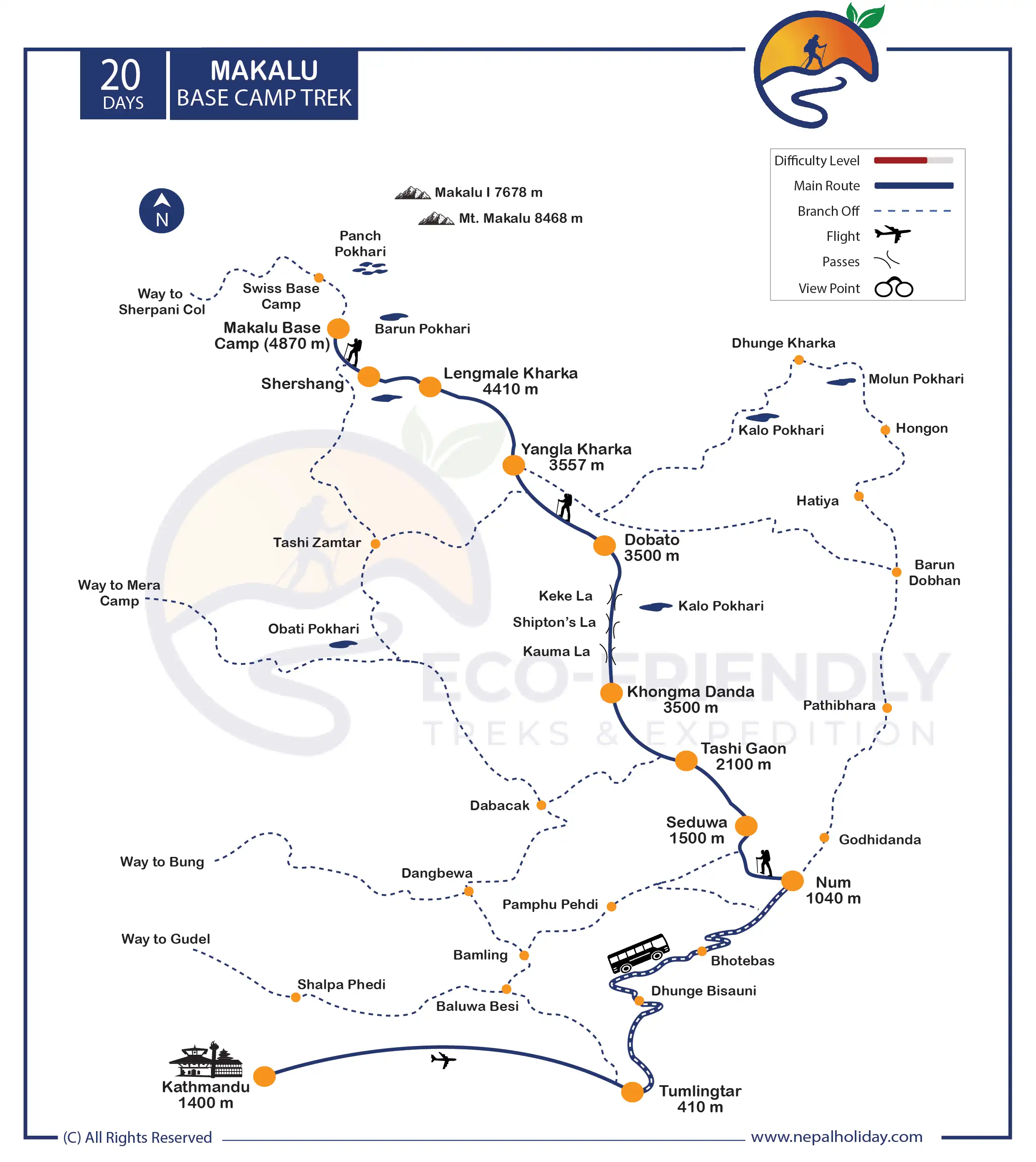
Makalu Base Camp Trek Route Map
After 25 minutes, we will fly from Kathmandu to Tumlingtar and drive to Chichila. This trek takes you through the scenic nature and settlements of Num, Tashigaon, Dobate, Yangri Kharka, and Makalu Base Camp. The trek will take you through beautiful mountain scenery and charming communities surrounded by Sherpa and Tibetan people. Around every edge is a fascinating glimpse of the high Himalayas, with entire horizons opening up to you as you reach the high points of your trek. We will return on the same route to Tumlingtar and fly back to Kathmandu. You can look at the infographic image of the map of Makalu Base Camp Trek for a basic idea.
Is the Makalu Base Camp Trek Difficult?
Undoubtedly, the Makalu Base Camp trek is one of the most technical and challenging trek. Since the area is one of Nepal’s most unexplored and remote areas, it is a challenging journey. Along with that, during this difficult walk, you will ascend over 5,000 meters. There is also a possibility of altitude sickness if done incorrectly.
You must be mentally and physically fit to take part in this trek. We suggest you jog, visit the gym, or go on a few short treks around the area. The trail is challenging. However, with our expertly prepared Makalu Base Camp Trek itinerary, appropriate guidance, and months of tough preparation, you will receive the adventure of a lifetime and spectacular natural beauty.
Itinerary of Makalu Base Camp Trek
We will have an early morning adventurous flight from Kathmandu to Tumlingtar. This flight will generally take 35 minutes. During the flight, witness the incredible views of mountains and clouds from the window.
After then, we will drive for 4 hours to reach Chichila. With thrills and adventure for the first half an hour ride, we will drive uphill to reach Kandbari. From there, we head through fields, Gurung village, and forests to get to Chichila.
Today will be the first day of the trek, and you will check the permit at the police checkpoint. After that, we will trek through the lush Himalayan forest of rhododendron and a small forest. After passing through the green hills and small villages, you will finally reach Num. During the stay, you may notice a small glimpse of peaks from a distance.
Your trek starts with the steep descent to the Arun River, which takes around 2 hours. During the descent, you will get through the rivers and cardamon crops. The path passes through the stone steps to the river. You will also cross the suspension bridge over the Arun River.
After crossing the bridge, we will gain the height to reach the Seduwa. You will cross through the bamboo forest and bustling village life along the trek. We will also need to cross the checkpoint of Makalu Barun National Park.
Today the walk will be a little easier with a beautiful view. The initial phase of the trek contains several stone steps and mani walls, which lead you to the Sherpa community. You will be able to notice several small farms on the hillside, a cardamon plantation, and a rhododendron forest.
Today you will experience a varied walk. After approximately 2 hours of trek, you will reach Chyaksa Danda village. You will notice a small school, a tea shop, and small houses. After crossing through the dense forest will cross a few streams and small bridges. After the walk, you will reach Tashigaon. You will see the fantastic view of the Himalayas from the Tashigaon.
Today you will have a lot of ascents. The initial phase of the trek starts to ascend from Tashigaon and hear toward the stone steps. After some hours of walk, you will cross another small bridge and continue the walk inside the beautiful rhododendron forest. If you are here in April, enjoy the stunning rhododendron and magnolia trees blooming with a white peak in the east.
After walking for about 3 hours, you will reach Dhara. After you leave Dhara, start a stiff climb for about 1 hour to reach Unshisa. After a couple of hours of walking from Unshisa, you will finally reach Khongma Danda.
Finally, we will give time to adapt the body to the high altitude. We strongly recommend you walk for some hours during your acclimatization periods too. If you want a shorter walk, visit the nearby monastery and see the sherpa culture and way of life. If you want some adventure with a mind-blowing view, then climb to Kongma La. It will take around an hour to reach the pass. After enjoying the view, retrace your steps back to the lodge.
Today is truly spectacular, crossing four high passes with airy traverses and dramatic ridge sections offering near-constant stunning views of snow-capped peaks. We will not have lunch until you reach Dobato, so make sure you take plenty of snacks and water.
We begin by ascending over Kauma La Pass (3603 m), and from there, we continue to Keke La Pass (4127 m). We continue to ascend until we reach the Shipton La pass (4170m). A mani wall and cairn close to the shelter serve as markers for the pass. They are both decorated with prayer flags. Although not difficult, the pull-up to the Shipton La is quite steep. Then, after a couple of hours of walking and passing through the Tutu La Pass (4080m), we arrive at Dobato.
After the early morning breakfast, we will start to descend through the beautiful forest of pine and rhododendron. Look out for different species of colorful birds in the trees.
We trek towards Yangla Kharka while traversing thick rhododendron forests and crossing the Barun River. Yaks could be found grazing in the field as we travel. When you finally reach the river, you start walking along a path beneath a sizable landslide area. You can catch glimpses of Mt, Chanlang and Mt. Tutse. After 7 hours of trek, we reach Yangla Kharka. Overnight at a lodge in Yangla Kharka.
Starting smoothly and flatly, keep the river to your left. The trail is lined with numerous vibrant prayer flags. It’s a truly beautiful day, with craggy snow-covered summits, sheer cliffs, cascading waterfalls, and sacred caves serving as a visual feast.
To get to Merek, we hike through dense Himalayan forests and cross a few wooden bridges over small streams. Take it slow and steady here as you will be feeling the altitude as you toil up towards Langmale. As you limp up towards Langmale, you’ll start to feel the altitude, so go slowly and steadily.
As we make our way to Langmale Kharka, we pass through moraines and small Himalayan villages as we pursue the mountain view.
The going is difficult at this altitude, but you’re on a good path as you start your ascent. To get to Shershong, we walk through icy glaciers and ridges while ascending a rocky path next to Barun Nadi. While winding your way around the valley, keep the river to your left.
Every bend will present you with a different dramatic view of the surroundings. While traveling to the base camp, we take in the splendor of Mt. Makalu (8481m). We hike for about an hour before arriving at Makalu Base Camp. Its formidable face, with its icefalls, crevasses, jagged edges, and seracs, makes you wonder. Around the base camp, you might see a lot of Tibetan snowcocks, hill pigeons, black redstarts, and mountain finches.
At the height of about 5,300 meters, the ridge offers the most beautiful panoramic views. Today, we explore the area around Makalu Base Camp while enjoying a stunning view of the Himalayas in eastern Nepal, including Everest (8848m), Lhotse (8516m), and Makalu from the south face. We enjoy the surrounding glaciers’ and lakes’ natural beauty.
Retrace your steps to the base camp when you fill with mountain drama. The round trip should take around 4-5 hours. It’s a demanding trek because the steep path and the altitude will affect you above 5,000 meters.
With a heavy heart, we will leave behind Makalu Base Camp. On our way to Yangri Kharka, we pass the small villages of Shershong, Langmale Kharka, and Merek as we hike through sparse forests along rocky trails.
Walking alongside the Barun River, you will pass through alpine forests, rocky ridges, and small streams. Just before Themathang, you can see a small bridge you can cross. It is decorated with prayer flags. We will eventually have to navigate a landslide area and some narrow passageways. As you draw closer to the Dobate, the ascent gradually eases, and the going becomes easier.
You have just one more chance today to enjoy the breathtaking views of tall mountains like Kangchenjunga. Our journey to Mumbuk takes us through fir, juniper, and rhododendron forests. You will need another hour and a half to get to the Shipton La, today’s highest point at 4,200 meters. After another hour or so of contouring around the mountainside, you will reach the small cairns that mark Sano Pokhari Danda at 4,105m.
A further hour of walking brings you back to the final pass of Khongma La. You return to Khongma after a roughly 250-meter descent, most of it down stone steps.
We walk through thick forests and pass by a few lakes as we move forward. Trekking along steep rocky trails, we pass through Makalu Barun National Park and enter the beautiful Sherpa village of Tashigaon.
We pass the remote Barun River valley and settlements while hiking along small streams. To get to Seduwa, we trek with Isuwa Khola on one side and Hingsa Khola on the other.
To leave Makalu Barun National Park, we trek through a number of dense bamboo and rhododendron forests and cross the Arun River. While traveling to Num, we pass a small Sherpa village in the countryside.
Our trek is coming to an end today. To catch the bus from Tumlingtar, we will make the approximately one-hour trek to Chichila. Before arriving in Tumlingtar, we enjoy hiking along difficult terrain while taking in the stunning view of Mt. Makalu (8481m). We will eventually come to Tumlingtar after the long ride.
Includes/Excludes
What's Included?
- Bus Fare during the trek as per itinerary
- Domestic Flights for KTM to Tumlingtar to KTM
- Permit Cards Expenses
- Experienced Himalayan trek guide for 19 days
- One porter for two of you for trekking for 17 days (prepare to give max. 15 kgs’ luggage from each of you so that it will not exceed 30 kg. for your porter)
- Basic yet comfortable accommodation for 18 nights on a twin-sharing basis during the trekking as per itinerary.
- Staff insurance
- 18 x set breakfast, 18 x set lunch and 18 x set dinner while on the trek
- Purified drinking water during the entire trekking as per itinerary
- General first aid medicine kit
- Complimentary T-shirt
- Duffle bag during the trek
What's Excluded?
- International Flight Fare
- Accommodation in Kathmandu since there are many possibilities available
- Personnel expenses of any kind
- Any Travel Insurance
- Any additional cost due to natural calamity and unforeseen circumstances
- Tips for any staff and guide
- Anything that is not listed in the “PRICE INCLUDES” section above
Essential Information - Makalu Base Camp Trek
Makalu Base Camp Trek Permit
Permit types required for the Makalu Base Camp trek are the Makalu Rural Municipality Permit and Makalu Barun National Park Entry.
These are all preserved areas, and all the fees paid for permits will be utilized to improve the area.
For more information, please visit: Trekking Route and Permit Fee
Note: In most cases, while preparing official paperwork, you will be required to submit passport-size photos and a copy of your passport. So, be sure to bring at least 8–10 passport-size photos. We will complete all legal requirements and acquire all required permits for your trip.
Accommodation on Makalu Base Camp Trek
There are only a few very basic tea houses, along with the main stations, available in the area. To find accommodation, you must be well-paced and capable of walking a particular distance. There are few lodges along the route, especially while reaching Khongma Danda.
The tea house and lodge will be very simple during the Makalu Base Camp Trek. The rooms are basic twin-sharing setups with blankets, pillows, and beds. Since private rooms are unavailable, you must share the space with your companion.
Since tea house trekking in the area is still relatively new, they have a minimum of basic facilities. Nevertheless, our team works to ensure you have the most comfortable accommodations during your visit.
Please be informed that we will provide you with accommodations only during the trek. While staying in Kathmandu, you should pay for your hotel yourself. There are numerous options of hotels available, and we want you to stay wherever you feel comfortable. We are always available if you need any suggestions on hotels.
Food on Makalu Base Camp Trek
You won’t be eating anything spectacular while on the Makalu Base Camp Trek because this is one of Nepal’s most remote regions. Because there are no roads in the trekking area, they are transported by men and donkeys. It will undoubtedly require a lot of effort.
Similarly, your lunch and breakfast will consist of varied foods, such as soup, noodles, pasta, Tibetan bread, toast with jam, chapati, scrambled or boiled eggs, and more.
Similar to how your lunch will always include the traditional Khana set with rice, dal, curries, pickles, and other side dishes. You get the necessary protein from this cuisine to travel the terrain.
Please be aware that we will serve you three meals during the trek. The cost doesn’t include meals in Kathmandu. Because of the variety of food options available here, we let you explore breakfast, lunch, and dinner by yourself. We can also manage your food service in Kathmandu upon your special request. For that, please let us know while customizing your trip.
Best season to trek Makalu Base Camp
Spring (March–May) and autumn (September–November) are the best times for the Makalu Base Camp trek. Especially at low and moderate heights, the temperature and weather look great.
You can enjoy the incredible mountain views and landscapes when the weather is clear. The pathways provide a fantastic view of the magnificent peaks. Everything can be seen clearly during this season, mesmerizing you, from the tiny communities beneath to the stunning glaciers that have formed.
Also Read: Best Time to Trek in Nepal
Altitude Sickness and Acclimatization of Makalu Base Camp Trek
Since the Makalu base camp trek requires a lot of ascent to higher altitudes, many trekkers will experience altitude sickness while participating in the journey. Due to this illness, many hikers won’t be able to do Makalu base camp trek.
The trek is done gradually and slowly with proper acclimatization to avoid or resolve this issue. The route is set up to prevent covering a significant elevation all at once.
But this surely is not enough. We request that you train your body correctly, keep exercising, and maintain your diet for at least three months before the trek. It is crucial to keep this in mind to protect yourself against altitude sickness.
Makalu Sherpani Col Pass Trek Packing Suggestions
Please properly pack your luggage for the porter (each of you weighs 15kg; for two of you, a porter is arranged). You will leave the rest of your luggage behind at your hotel until the end of this holiday. Below is a loosely advised Makalu Base Camp Trek packing list that might help you on your trek:
- Appropriate clothing (3 sets)
- Woolen sweater or jacket
- Thermal inner wear
- Wide-brimmed hat
- Woolen cap and scarf
- Thick woolen gloves
- Water-proof gloves
- Sport Sandals
- Woolen socks (2 pairs)
- Water-proof (not water-resistant) shoes with a good tread/grip
- Rain-proof pants and jacket with hood
- A lock for the duffle bag
- Backpack with water-proof cover
- Sleeping bag suitable for temperatures around 0°C (optional)
- Down jacket with hood
- Camera (optional) (video camera is not permitted by authority)
Other essential items:
- Personal clothing
- Toiletries
- Small thermos for hot beverages
- Water bottle (1 liter)
- Sunscreen lotion (50 SPF or more)
- Castor oil (50 ml) to lubricate the nostrils at high altitude
- Ziplock bags for clothing
- Quick-dry Towel (not a regular one)
- Toilet paper
- Wet wipes
- Sunglasses
- Snacks: chocolates, biscuits, nuts, etc.
- Hand sanitizer
- Powerful flashlight or headlamp (with extra batteries)
Medical Kit
Though we arrange basic medical kits for Makalu Base Camp Trekking, they are very general and may not be adequate based on conditional necessity. A personal medical kit with electrolyte packs, pain killers, muscle relaxant cream, band-aids, knee caps, medicines for fever, common cold, headache, nausea, vomiting, diarrhea, indigestion, and any other personal medication is necessary from your side.
Communication in Makalu Sherpani Col Pass Trek
The Makalu Base Camp Trek itinerary encounters different landscapes. Even in this age of highly modern information and communication technologies (ICT), it is challenging to approach development in remote areas. One cause of this is still not correctly developing the technologies. As communication is significant in such an area, a guide has a mobile that may help connect you with a networked area. The lodges also have telephones you can call for a certain price. Wi-Fi may be available in very few places on this route.
Most asked questions
FAQs about Makalu Base Camp Trek
For decades, it has been experienced that Himalayan existence helps to create and realize an unneedy division of joyful wholeness. Your presence in the mountains, whether as a hermit or a pilgrim, has long been associated with the attainment of blissful wholeness.
Either Zen or Jesus concerns Himalayas, mountains, and hermits in the forest (Banbas). Himalaya has that aura to help unite unneeded divisions so that joyful recreation can be realized.
With this, we believe that trekking in Makalu Base Camp is more than just a trip; what you feel depends upon your interest and state of awareness.
Makalu Base Camp, with a height of 4870 m/15977 ft, is the highest point on the Makalu Trek. Every bend will present you with a different, dramatic view of Mt. Makalu and its surroundings.
The daily travel usually lasts between 6-8 hours with short breaks. However, the actual time depends entirely on your walking speed.
Yes, beginners can also trek Makalu based on their health conditions. No other climbing or other skills are required as part of our package; you can walk on the rocky trails. Therefore, you will be prepared for the trek if you are well-prepared to get over this fear.
Just make sure you get yourself mentally and physically ready with basic exercises like jogging, breathing exercises, or swimming before three months of the trek. Beginners might be afraid of spending the entire day on the rocky paths, but being fully physically and emotionally prepared will give you more confidence to take on the challenge.
An entry permit is compulsory if you travel for any reason in the Makalu region. And, for the permit for the Makalu trip, you will need the Makalu Rural Municipality Permit and Makalu Barun National Park Entry.
A TIMS card was once required for the Makalu trek as well. But with the new rule, it is now displaced by the permit system during the trek.
The permit is related to your safety while traveling into the conserved areas. It ensures your safety while trekking into those areas, and the fee you pay is also utilized for the betterment of the area to make it visitor-friendly.
Yes, with our assistance, you can extend or minimize the itinerary for the Makalu trek since we have already given you one of the best routes. We want to warn you ahead of time that if you are not used to high altitudes. So, cutting back on the number of trekking days might not be the best idea.
However, if you want to spend more time in the Himalayas, we can change your itinerary to suit your needs. Reducing the itinerary may lead to a lack of time to adjust to changes in the environment, humidity, or pH, which may lead to high altitude sickness and other problems. To compensate for the lower oxygen saturation in the blood at high altitudes, your body must have time to produce more red blood cells.
But if you are willing to spend more time in the Himalayas, we have the best other options to extend the itinerary days or even extend the trip with other packages and customize it per your demand. Feel free to get in touch with us; our team will provide you with your dream package under your priorities and our guidance.
You must travel with the guide if you purchase the package from a trekking service. We care for your safety when you travel with a local agency like us. If you are with a guide, the team always provides a better option in selecting the accommodation, food, end language barrier, and even the itinerary selection. They will also help you with permits, domestic flights, and porters and assist you with your entire trek.
Additionally, if you encounter high-altitude sickness, you will have knowledgeable staff by your side to monitor your symptoms from the very beginning. They will be familiar with such high altitudes and wildlife and will assist you in learning at every step. It is not compulsory to take a guide for this trek if you are an independent trekker, but your trek will be hassle-free if there is a guide with you.
The battery will quickly drain if it is in a cold environment. So you need to charge your device more frequently. You can recharge the battery in the lodge where you spend the night. They will charge you more because the lodge uses solar energy.
Make sure to take a spare battery or a portable power bank as a backup during the Makalu Base Camp trek. It is best to carry extra batteries because there may occasionally be power outages or low voltage.
It is important to check health and fitness when traveling through high-altitude regions. It helps to ensure a safe and comfortable experience for all the trekkers.
We are happy to welcome you to the Makalu Base Camp Trek with your family and kids, as we believe nature helps kids in different ways. With a professional guide, the trek can be done smoothly. But we will not advise bringing the children at an inappropriately low age (lower than 15 years) for high-altitude walking.
Prepare your kids with simple workouts and breathing exercises for at least 1 month to prepare for this trek. We also provide a kid-carry service, so kindly let us know during the inquiry if you need one.
Reviews on Makalu Base Camp Trek
Be first to post a review in this trip.
© Copyright 2024 Eco-friendly Treks. Website Developed by: AVIVA