


Trip Introduction
Overview of Manaslu Circuit Trek
Feelings of joy result from realizing an interest in immersing in the Manaslu Circuit Trek. The guidance to the Manaslu existence helps to satisfy your deep desire to be in the historical Himalayas.
In local terms, Manaslu means “mindfulness.” Popping up and becoming interested in your mind realizes joyful wholeness, a high state of quality recreation. The notion of Himalayan wisdom (awareness) is flexibly applied to transform interest in you to be in Manaslu’s existence toward joyful wholeness.
Interest in Manaslu’s existence is valued as a transcended interest. To be at home, enjoy the homely environment, travel, and choose luxurious means of facilities (transport, meals, accommodation) is a normal interest that almost all human beings in almost all periods have. Interest in remote Himalayan existence, such as at Manaslu, is understood as a transcended interest.
Such interests may have that mindful intensity that can realize and transform you into joyful wholeness. This interest or will to be in existence, which helps “nothing to be in mind,” often has such intensity. Born in Himalayan existence and guiding in the core, central Himalayan existence since 1990, it has been observed that a rekindled interest in being in the Himalayas frequently awakens and transforms you toward wholeness.
Manaslu Trekking may be an ideal destination if you want to immerse yourself in the Himalayas. Hopefully, the perfect goal is for you to realize harmony, compassion, love, togetherness, and joyfulness, which is wholeness.
We have designed Manaslu trekking so that we may adapt to your preferences and enrich your holiday experience. We welcome you to join the Manaslu Circuit Trek holiday to be in joyful wholeness.
Manaslu Circuit Core Trek
In the world of a concrete jungle, the tranquility of green and open space is highly craved. Just being out in nature may do wonders for our mental health and help us see things from a holistic perspective. Being outside in the fresh air and surrounded by natural beauty sharpens our senses and helps us tune in to our inner experiences.
Walk in the Manaslu existence and appreciate the surroundings, using all of our senses to immerse ourselves in the present. We organized a fixed departure for the Manaslu Circuit Trek in autumn and spring, when the weather is best for trekking.
Manaslu Circuit Yoga Trek
We are usually overburdened with toxins due to our workload or a particularly stressful period. Practicing yoga in Manaslu mindfully can make us feel more alive, fulfilled, and connected to ourselves.
The trip continues with yoga while immersing in the beautiful natural surroundings of Manaslu. Being in Manaslu and relaxing your body in nature takes us back to a state of consciousness. The trip will take place in September, when the weather and environment are perfect for yoga.
Manaslu Circuit Celebration Trek
Celebrations give us a chance to forget about our worries and look at the good things in life. It also gives people a chance to get along better and brings people closer together in a bond of love.
In the Manaslu Circuit Trek Celebration, we take this time to celebrate the holiday together. The trip will start at Buddha Jayanti in June and at Tihar in November.
Itinerary of Manaslu Circuit Trek
We will start the trek with the fantastic drive through the Prithvi Highway up to Malekhu, head towards Dhading, Arughat, and then to Soti Khola. It takes 6 to 7 hours to reach Soti Khola if you catch the direct bus.
The road is quite bumpy and dusty until Malekhu. Enjoy the fantastic landscape, fast-flowing rivers, and small settlements from the window seat during the ride. During the drive, you will have several stops for short breaks.
Today, you will start your actual trek after enjoying the morning breakfast. The sound of the river, the scenic landscapes, and the warm breakfast give you incredible energy for the trek. The initial phase of the track is on an uneven road until you reach Machha Khola.
During the walk, you will notice the stunning countryside view, fast-flowing river, and greenery, which make your walk unique on the first day. These beauties will help to keep you engaged throughout the trail.
As you walk further, you cross the Sal forests, rivers, waterfalls, and towering cliffs. You will also be able to encounter Gurung and Ghale people in this area. You might feel good having Dal Bhat, seasonal vegetables, and other typical dishes during the trek.
Furthermore, we will follow the river trail and reach Nyali Khola. We will have several ascents and descents across the winding road. You will also share the path with several mules, so be careful. Always stand on the corner side of the track to avoid slipping down to a fast-flowing river or hillside.
With these unique experiences, you will finally reach the Maccha Khola for a night’s stay.
We will start our trek along the twisting road on the bank of the Budi Gandaki River. After some hours of walking, you will enter the dense forest where monkeys and langurs can be seen in the hills and trees. As the forest ends, you will reach the Gurung village wearing the typical browned cape called “Bokkhu.”
After heading ahead, you will reach Tatopani, or “hot water.” You can also take a natural hot shower and relax your muscles. After some time, you will be crossing the suspension bridge over Budi Gandaki. After crossing the bridge and walking for some minutes, we will finally reach Doban.
After some hours of walking, we will cross a wooden bridge to the left of the Buri Gandaki river. After some hours of ascending, we will reach the Gurung settlements. Following the trail and river, you will then get to Yaru.
After some more walking, you will finally reach a long cantilever bridge to Jagat. This village is a clean, flagstoned Gurung village in the Green Hills’ lap. We will also get our permit checked in this village.
From today we will be crossing the restricted area. Several stupas and Buddhist flags can be seen on the trail as you approach. As you reach Philim, your permit is again checked, and you continue along the western bank of the river.
Ahead of the trail, you will notice a unique sculpture over the big stones on the bank of the river. While living in the area, you will pass through a dense forest of rhododendrons, pine, and wild animals. You will also notice the small peaks in the distance. Walking further, you will reach Pewa.
After the early morning breakfast, we will have our breakfast and be back on the trail. You will begin to pass through the bamboo forest and then ascend the winding paths to reach Deng. As you walk further, you get a suspension bridge and climb toward Bihi Phedi. While walking on the trail, you may encounter a white-faced monkey for food in the village.
After crossing this village, you will proceed to Ghap village. To reach this village, you must cross several narrow and landslide zones. Be more attentive while walking the landslide trail. After some hours of walking, you will then head towards Namrung.
To reach Namrung, it takes about 1 hour on this uneven path. Still, you will be following the river to get to the Namrung. You will be greeted by the mighty Manalsu and several other peaks while reaching this village.
Today you will leave the Namrung village and the Nubri people living in these villages. The people here have a typical Tibetan-influenced lifestyle. Ahead, you will pass through the beautiful rhododendron forest, lush terraces, and white peaks. You will pass through several villages like Lihi, Sho, and Lho. You will see fine paintings, stupas, and apple farms upon reaching here. On the way, you will also witness the stunning views of Manaslu (8163m) and Manaslu North (7157m).
Slowly, you will gain altitude, so you must give your body time to adjust to this environment. Walk slowly and do not panic if there is a mild headache or uneasy breathing. This typically happens at high altitudes.
As you cross the Lho, Mt. Manalsu will accompany you with the best view. You will cross Shyala while crossing rhododendrons and pine forests with mosses in the steam. From Shyala, you will finally reach Samagaon. Upon reaching this village, you will see the best view of Manalsu and many stupas and Nubri people. This village also holds a small health post, many shops, telephones, and a heliport.
Today you will get a chance to acclimatize your body to a high altitude, so there is no risk of altitude sickness. If you want to be at the base of this mighty Manalsu, walk for 5 hours to reach the base camp. You can take your lunch there and use it to gain energy. You can follow and witness the Birendra Lake and turn left onto the base camp track.
You can also walk to the Pungyen Gompa east of Nubri Valley. You will walk along the roaring river for two hours on the trail. Upon reaching there, you will witness the different perspectives of Mt. Manaslu and, if lucky, see Yaks and Thars.
Today we will walk a short distance because you are gaining height rapidly. Today you will notice the vast yak pastures in the broad valley. You will also experience the long mani walls and farming fields. You will also notice there is no tree line. You will see bush-type vegetation or barren land at this altitude.
From there, we will climb a ridge across the wooden bridge of Buri Gandaki before reaching Kani. After a few hours of trekking, you will get to Samdo. If you have more time, then visit Samdo Peak. You can see the main track for Tibet over Larkya La forming a slope on the Larkya La trail.
Today is another day of acclimatization in Samdo. You will have a day trip to the Tibetan border on a free day. You can see the Tibetan side and the yak caravan passing the border. You will also get to see the south side of Samdo Glacier. The excellent view of the huge serac near the top of the glacier makes you feel heartfelt. After quality time at the border, you will return to Samdo and have some rest.
Today is another adventurous walk to Dharmasala. Watch your body sign and stroll and give time to your body. Also, enjoy the great scenic view of the Himalayan chain. You will slowly walk across the rugged terrains before you reach Dharmasala.
Today is unique as you will step foot on the highest point of this trek. Today, you will cross the Larkye La Pass at an altitude of 5160 meters. You will have to wake up early, at 3 or 4 AM, have breakfast, and start the trek. Today’s environment is quite harsh and challenging. This is the hardest part of the trek, but you will cross it.
Find inner peace once you see a foot at the top of the pass. You will notice the top, designed with the prayed-for flags and signboard. Witness the beautiful peaks of Himlung, Kang Guru, and Annapurna II.
After spending a particular amount of time at the top, start another challenging part to reach the Bumthang. You will have to descend vertical slop land with loose gravel stones. So, there is a high chance to heart your leg here, so be extra careful while walking. While descending, you can see the huge icefalls in all directions. After about 3 hours descending from the top, you will reach Bumthang.
Today will be the end of your trekking after you reach Dharapani. You will walk downhill through the lush forest full of flora and fauna. You will walk across the Dudh River and get to Karche. After some hours of walk-in in a dark forest, you will reach Gurung village. These are the actual Gurung settlements after Bhimthang.
The valley is more mush, and the soil is favorable to agriculture too. You will pass through various agricultural fields and forests. After some hours of trek, you will finally reach Dharapani and Tilije.
You will have a short drive from Tilije from Jeep. After that you will change to a bus. After 6 to 7 hours of ride from Kathmandu, you will finally reach Kathmandu.
Includes/Excludes
What's Included?
- Bus Fare during the trek
- Permit Cards Expenses
- Experienced Himalayan trek guide for 13 days
- One porter for two of you for trekking for 12 days (prepare to give max. 15 kgs’ luggage from each of you so that it will not exceed 30 kg. for your porter)
- Basic yet comfortable accommodation for 12 nights on a twin-sharing basis during the trekking as per itinerary.
- Staff insurance
- 13 x set breakfast, 13 x set lunch and 12 x set dinner while on the trek
- Purified drinking water during the entire trekking as per itinerary
- General first aid medicine kit
- Complimentary T-shirt
- Duffle bag during the trek
What's Excluded?
- International Flight Fare
- Accommodation in Kathmandu since there are many possibilities available.
- Personnel expenses of any kind
- Any Travel Insurance
- Any additional cost due to natural calamity and unforeseen circumstances that may lead to a change in itinerary.
- Tips for any staff and guide
- Anything that is not listed in the “PRICE INCLUDES” section above
Departure Dates
| Date | Duration | Price | Availability | Join |
|---|---|---|---|---|
|
Apr 19, 2024 - May 02, 2024 |
14 Days | US$ 901 | Available | |
|
Apr 26, 2024 - May 09, 2024 |
14 Days | US$ 901 | Available | |
|
Apr 30, 2024 - May 13, 2024 |
14 Days | US$ 901 | Available | |
|
May 03, 2024 - May 16, 2024 |
14 Days | US$ 901 | Available | |
|
May 10, 2024 - May 23, 2024 |
14 Days | US$ 901 | Available | |
|
May 17, 2024 - May 30, 2024 |
14 Days | US$ 901 | Available | |
|
May 24, 2024 - Jun 06, 2024 |
14 Days | US$ 901 | Available | |
|
May 31, 2024 - Jun 13, 2024 |
14 Days | US$ 901 | Available | |
|
Jun 01, 2024 - Jun 14, 2024 |
14 Days | US$ 901 | Available | |
|
Jun 07, 2024 - Jun 20, 2024 |
14 Days | US$ 901 | Available | |
|
Jun 14, 2024 - Jun 27, 2024 |
14 Days | US$ 901 | Available | |
|
Jun 21, 2024 - Jul 04, 2024 |
14 Days | US$ 901 | Available | |
|
Jun 28, 2024 - Jul 11, 2024 |
14 Days | US$ 901 | Available | |
|
Sep 01, 2024 - Sep 14, 2024 |
14 Days | US$ 901 | Available | |
|
Sep 06, 2024 - Sep 19, 2024 |
14 Days | US$ 901 | Available | |
|
Sep 13, 2024 - Sep 26, 2024 |
14 Days | US$ 901 | Available | |
|
Sep 20, 2024 - Oct 03, 2024 |
14 Days | US$ 901 | Available | |
|
Sep 27, 2024 - Oct 10, 2024 |
14 Days | US$ 901 | Available | |
|
Sep 30, 2024 - Oct 13, 2024 |
14 Days | US$ 901 | Available | |
|
Oct 04, 2024 - Oct 17, 2024 |
14 Days | US$ 901 | Available | |
|
Oct 11, 2024 - Oct 24, 2024 |
14 Days | US$ 901 | Available | |
|
Oct 18, 2024 - Oct 31, 2024 |
14 Days | US$ 901 | Available | |
|
Oct 25, 2024 - Nov 07, 2024 |
14 Days | US$ 901 | Available | |
|
Oct 31, 2024 - Nov 13, 2024 |
14 Days | US$ 901 | Available | |
|
Nov 01, 2024 - Nov 14, 2024 |
14 Days | US$ 901 | Available | |
|
Nov 08, 2024 - Nov 21, 2024 |
14 Days | US$ 901 | Available | |
|
Nov 15, 2024 - Nov 28, 2024 |
14 Days | US$ 901 | Available | |
|
Nov 22, 2024 - Dec 05, 2024 |
14 Days | US$ 901 | Available | |
|
Nov 29, 2024 - Dec 12, 2024 |
14 Days | US$ 901 | Available | |
|
Dec 01, 2024 - Dec 14, 2024 |
14 Days | US$ 901 | Available | |
|
Dec 07, 2024 - Dec 20, 2024 |
14 Days | US$ 901 | Available |
Special Group Discount Price
| Group Size | Price |
|---|---|
| 1 Person | US$ 1147 Per Person |
| 2 People | US$ 901 Per Person |
| 3 People | US$ 852 Per Person |
| 4-6 People | US$ 844 Per Person |
| 7-9 People | US$ 810 Per Person |
| 10-12 People | US$ 814 Per Person |
| Over 12 People | US$ 809 Per Person |
Essential Information - Manaslu Circuit Trek
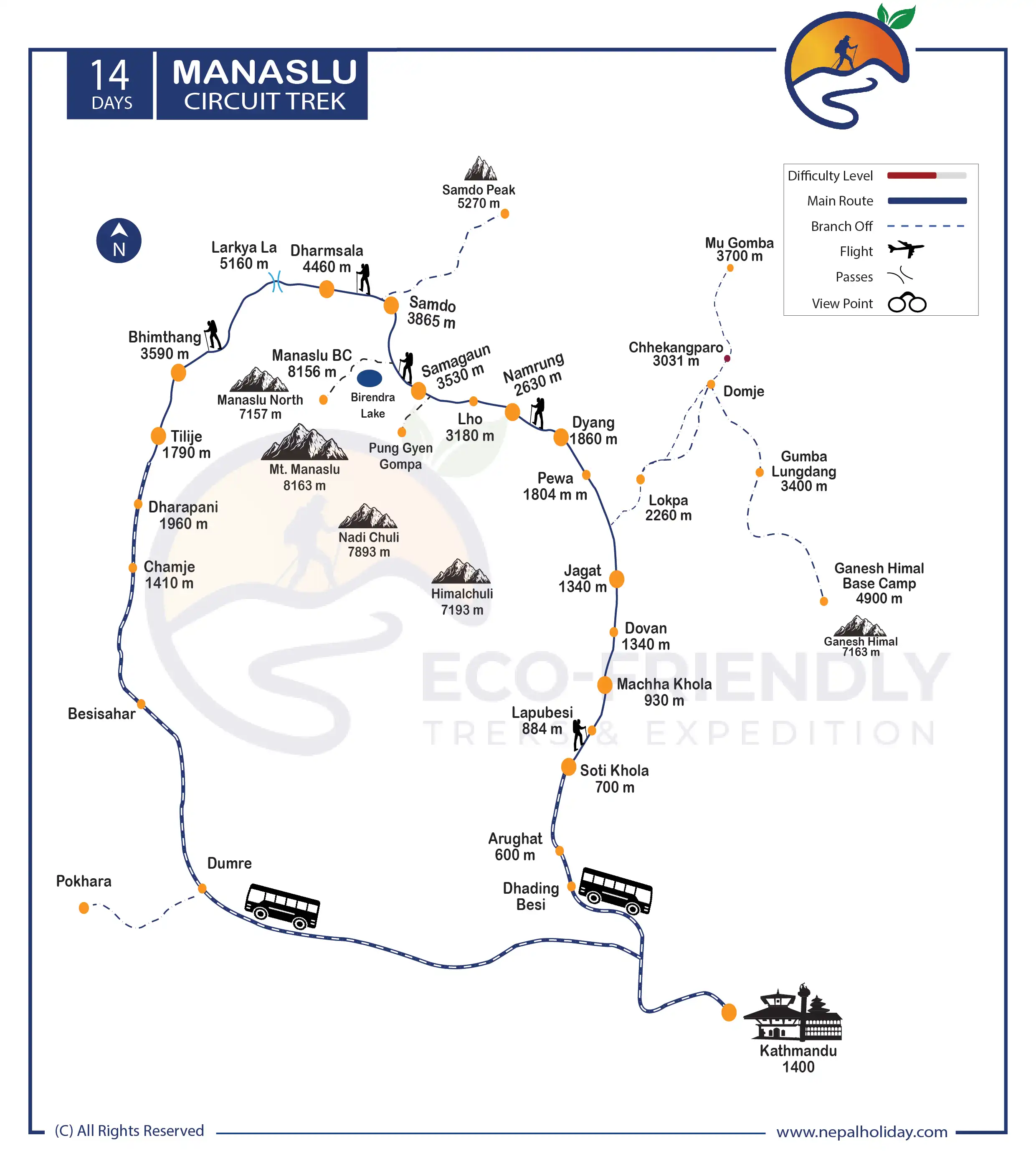
Manaslu Circuit Trek Route Map
Are you wondering about the map of the Manaslu trek? If you click on the infographic image below, you will see the route map for Manalsu Circuit. We have included every overnight stay and elevation reference on our map. Click on the infographic image below to find out about the route.
The Manaslu Circuit Trek distance is 14 days, starting with the scenic drive from Kathmandu to Soti Khola. The total length of the Manaslu Circuit trek is about 110 miles, i.e., 177 kilometers. However, the distance between the start point and the distance between the days of the itinerary differs. Our trek starts ahead to Soti Khola, Jagat, Namrung, Sama Gaun, Dharmasala, and finally to Larkey La Pass. We descend to Bimthang, Dharapani, Besisahar, and then Kathmandu. On the map, you will also see the extension route. Upon your interest, we can also extend the route to Tsum Valley for more exciting views.
Is Manaslu Circuit Trek Difficult?
The Manaslu journey is difficult physically and mentally due to its cliffs, large rocks, and steep routes. Long walking distances are necessary because of the rocky and isolated features of the area. The “Larkya La Pass” presents the toughest adventure on the Manaslu Circuit treks.
As you climb, there will be fewer trees to shelter you from the snow, sun, and wind. Regardless of your experience or the number of times you have made this walk, you still risk getting altitude sickness if you do not take the necessary precautions.
However, the Manaslu Circuit is one of the best alternatives for trekkers looking for excitement. Your physical fitness greatly influences the difficulty of the Manaslu Circuit Trek.
It would be best if you allowed yourself enough time to prepare before beginning the hike because it is a lengthy journey. To conquer the rough terrain of Manaslu, you must have physical stamina. Therefore, if you are a beginner, start with simple yet effective exercises.
Before traveling to Nepal, prepare for a day hike of any length. Just make sure it is on a mixed-use trail. Exercises that increase endurance power without stress also include jogging and cycling. Maintain a tight diet and an intensive exercise program to stay healthy and prevent altitude sickness.
Manaslu Circuit Trek Permit
For the Manaslu Circuit trek, you need to obtain three special permits: the Manaslu Restricted Permit, Manaslu Conservation Area, and the Annapurna Conservation Area (ACAP).
Entry permits are only valid for one entry, are nonrefundable, and cannot be transferred. Along with Manasalu, you also need to purchase an Annapurna Conservation Area Permit. It is because you pass through the Annapurna Conservation Area while trekking Manaslu.
For more info; please visit: https://www.immigration.gov.np/page/trekking-route-and-permit-fee
Note: In most cases, while preparing official paperwork, you will be required to submit passport-size photos and a copy of your passport. So, be sure to bring at least 8–10 passport-size photos. We will complete all legal requirements and acquire all required permits for your trip.
Accommodation on Manaslu Circuit Trek
The neighborhood residents themselves run the modest lodgings along the Manaslu. The tea houses were previously small wooden cottages with a room divided by wooden blocks.
However, some pretty good tea houses are built with more advanced technologies. The accommodations are simple: twin rooms with either separate baths or shared facilities. The beds usually have a mattress pad, blanket, and pillow, and they are cozy.
A central dining area with a heating system is always present and keeps the hotel warm. One can spend time with loved ones, unwind, chat with fellow trekkers, exchange emotions, and have coffee or tea in the evening.
Please be informed that we will provide you with accommodations only during the trek. While staying in Kathmandu, you should pay for your hotel yourself. There are numerous options for hotels available, and we want you to stay wherever you feel comfortable. We are always available if you need any suggestions on hotels.
Food on Manaslu Circuit Trek
The food menu on Manaslu Circuit Trek has a solid traditional Tibetan cultural impact. Thukpa is extremely popular, along with other conventional Nepalese cuisines like dumplings and chow mein. Warm vegetable and non-vegetable soup sets are also quite popular.
Gundruk Dhindo is the most significant among the various traditional Manaslu trek foods in the Himalayas, including dal bhat. The green vegetable Gundruk is fermented and frequently served as a soup. On the other hand, dhindo is a porridge made from barley, corn, millet, or buckwheat. This meal is recognized to be more energizing and long-lasting.
Protein, mineral, and carbohydrate-rich foods and beverages give you energy while walking on high-altitude treks like the Manaslu Circuit Treks. To make the travel experience more enjoyable, we focus on eating healthy foods and avoiding junk.
Please be aware that we will serve you three meals during the trek. The cost doesn’t include meals in Kathmandu. Because of the variety of food options available here, we let you explore breakfast, lunch, and dinner by yourself. We can also manage your food service in Kathmandu upon your special request. For that, please let us know while customizing your trip.
Best season to trek Manaslu Circuit
The ideal seasons for trekking on the Manaslu circuit are spring and fall. For the autumn window, ideally between mid-October and mid-December. The best time of spring is from the middle of March through the first week of June.
The ideal time to trek the Manaslu Circuit is during the above-mentioned seasons. This is the greatest time of year for whole Nepal trips and trekking in Nepal. The most awesome things you encounter during this time are clear, pleasant weather, a lovely atmosphere, and much happiness. Views of the snow-covered peaks above the lush valleys and ranges will be stunning.
Altitude Sickness & Acclimatization of Manaslu Circuit Trek
The trails above 4000m are challenging, regardless of how many times you have hiked this or the same level trail. While trekking, acclimatization is crucial, as is regular hydration. It involves using a variety of strategies to adapt to the changing environment.
There is less oxygen and air pressure in the atmosphere of the high-altitude region above 3000 m. It would help to avoid alcoholic beverages and caffeine while trekking, as they are the primary causes of dehydration. Drink water frequently to hydrate your body.
Altitude sickness is a severe condition; if anyone ignores it, the case can worsen and cause death. Most of the best treks in Nepal are at the highest altitudes. So, before you trek to the Manaslu region, you must know about the altitude sickness in Manaslu Circuit Trek: what it is and how to avoid it.
We request that you start exercising your body before you go high-altitude trekking. Join a gym, go hiking on rough terrain, and keep your diet in check. Following this helps you a lot during the trek.
Manaslu Circuit Trek Packing Suggestions
Please properly pack your luggage for the porter (each of you weighs 15kg; for two of you, a porter is arranged). You will leave the rest of your luggage behind at your hotel until the end of this holiday. Below is a loosely advised Manaslu Circuit Trek packing list that might help you on your trek:
- Appropriate clothing (3 sets)
- Woolen sweater or jacket
- Thermal inner wear
- Wide-brimmed hat
- Woolen cap and scarf
- Thick woolen gloves
- Waterproof gloves
- Sport Sandals
- Woolen socks (2 pairs)
- Waterproof (not water-resistant) shoes with a good tread/grip
- Rain-proof pants and jacket with hood
- A lock for the duffle bag
- Backpack with waterproof cover
- Sleeping bag suitable for temperatures around 0°C (1 – optional)
- Down jacket with hood
- Camera (optional) (video camera is not permitted by authority)
Other essential items:
- Personal clothing
- Toiletries
- Small thermos for hot beverages
- Water bottle (1 liter)
- Sunscreen lotion (50 SPF or more)
- Castor oil (50 ml) to lubricate the nostrils at high altitude
- Ziplock bags for clothing
- Quick-dry Towel (not a regular one)
- Toilet paper
- Wet wipes
- Sunglasses
- Snacks: chocolates, biscuits, nuts, etc.
- Hand sanitizer
- Powerful flashlight or headlamp (with extra batteries)
Medical Kit
Though we arrange basic medical kits for Manaslu Circuit Trekking, they are very general and may not be adequate based on conditional necessity. Personal medical equipment with electrolyte packs, pain killers, muscle relaxant cream, band-aids, knee caps, medicines for fever, common cold, headache, nausea, vomiting, diarrhea, indigestion, and any other personal medication is necessary from your side.
Communication in Manaslu Circuit Trek
The Manaslu Circuit trek itinerary encounters different landscapes. Even in this age of highly modern information and communication technologies (ICT), the landscapes are challenging for development in remote areas.
Most of the villages along the Manaslu Circuit Trek now have access to mobile phones and telephone services. Internet access is available in most tea shops, usually for a fee per hour. Wi-Fi is available in Lho, Samagaun, and a few nearby settlements. However, bad weather, such as heavy snowfall and rain, occasionally interferes with services.
Most asked questions
FAQs about Manaslu Circuit Trek
It has been known for decades that living in the Himalayas, like Manaslu or others, enables one to realize a joyful wholeness within oneself. Your realization of fullness within you has long been connected to your presence in the mountains, woods, or any other natural existence.
Himalayan or mountain ranges and hermits in the forest are topics of Zen to Jesus. The Himalayas have the power to bridge unneeded gaps and promote joyful enjoyment. Never undervalue your specific interests; they may be so appealing that they inspire you to achieve your goals and develop into a whole person.
In light of this, we honestly feel that the Manaslu Circuit Trek is more than simply a trip; nevertheless, how you experience it will depend on your degree of curiosity and awareness.
At 5,135 meters above sea level, Larkya La Pass is the journey’s highest point. You can see Annapurna II, Annapurna IV, Kang Guru, Himlung Himal, and Cheo Himal in all their majestic beauty.
You must get entrance authorization if you wish to enter the Manaslu region for any reason. Getting a specific trek permit is necessary to enter a protected area that the government has designated for trekking. You will need Manaslu Restricted Permit Fee, Manaslu Conservation Area Entry Fee, and Annapurna Conservation Area Entry Fee (ACAP).
The permit is for your safety while traveling into the conservation area. This permit fee is also used for the betterment of the national park.
For our fixed departure trip, you cannot change our itinerary. For that, we have a customizable package, so you can extend/reduce or make any changes to the packages we have built. You are free to explore your choices and redesign them upon our guidance.
Additionally, our itinerary is one of the best for all, so there may not be a reduced choice if you are a beginner in high altitudes. Reducing the itinerary may lead to a lack of time to adjust to changes in the environment, humidity, or pH, which may lead to high altitude sickness and other problems. Your body needs time to produce more red blood cells to counteract the lower oxygen saturation in blood at high altitudes.
But if you are willing to spend more time in the Himalayas, we have the best other options to extend the days and customize your itinerary per your demand. Feel free to get in touch with us, and our team shall provide you with your dream package under your priorities and our guidance.
If you are on a package tour, you must travel to Manaslu Circuit Trek with the guide. When traveling with a local agency like us, we will care for your safety. If you trek with a guide, they will provide a better option in choosing food and accommodation and also remove the language barrier. They will always be there to help you with permits, domestic flight arrangements, and local porters and assist you throughout the entire trek.
Additionally, if you experience high altitude sickness, your trekking guide will immediately monitor your symptoms. They will help you at every stage because they are familiar with the surroundings and the wildlife. If you are an independent trekker, it is not necessary to bring a guide along for this trek, but a guide will be helpful for a hassle-free vacation.
Your battery is more likely to drain quickly in a cold environment. So it would be best if you recharge your battery from time to time. You can charge your battery in the lower part of the trail where you spend your night, but as you reach higher, there is a low chance to recharge your battery. You must pay an additional fee if a charging service is available because the lodge uses solar energy to run the electricity.
However, you can bring a spare battery for your camera and other devices, so you won’t need to worry about charging it frequently. There might be a power cut or low voltage, so it will be best to carry the portable power bank.
As traveling through high-altitude regions, assessing your health and fitness is crucial. Every trekker’s experience is made safer and more comfortable, thanks to it.
Due to our conviction that children benefit from nature in various ways, we are pleased to welcome you and your family to the Manaslu Trek. With a professional guide, the trek can be done smoothly. However, we won’t suggest bringing kids who are too young (less than 5 years old) to go hiking at high altitudes.
For at least a month, prepare your kids for this trek by having them practice easy exercises and breathing techniques. Please let us know if you require a kid carry service during the inquiry process.
Before starting your journey to Manaslu Circuit Trek, we want to inform you that we have already paid for several things on behalf of you; permit, taxes, and others. Please also be aware that we must compensate our porters and guides even if you cancel or choose not to finish the trip because of their commitment to serving you.
Specific fees apply if you desire to cancel your reserved trips. Behind that, we welcome you to shift your trip days to Manaslu Circuit Trekking or the package itself. We may charge a specific amount of money if you wish to reschedule/cancel the booking date. Both parties will benefit if you inform us as soon as possible. Please go through our terms and conditions to clarify the refund process.
In case of hikers finish their journey sooner than expected or decide to terminate it early for any reason, kindly be aware that we do not grant refunds for any portion of the trek that is not used. This also totally depends on the circumstances, but we request that you not expect a refund for the above-mentioned reasons.
If the visitor does not reach our target within the period mentioned, the Manaslu Circuit Trek fixed departure package will be shifted to a customized package. The targeted and fulfilled travelers are updated in the date and price sections. We will surely let you know about every change.
Due to the party size, we offer you a very affordable price on a fixed departure. The Manaslu Trekking program will be revised if the group criteria are not met, which will change the price, including terms and conditions.
Note: We do not add or deduct the activities on the program of fixed departure. Please get in touch with us for the unique customized package if you create your itinerary rather than taking part in a fixed departure. Our team will happily assist you in your journey to Manaslu with their experienced advice and recommendations.
We highly suggest you engage in physical activities three months before the trip to prepare yourself physically and mentally. Additionally, we offer the Soldhunga Hike as part of our quick acclimation training trip. You can utilize this hike as a very tiny preview of what to expect on your main journey in the existence of the central Himalayas.
We request that you ask our ground team in Kathmandu for assistance in arranging day tours around the city. If you still have time extra few days or a week after the trek, we can also set up one of the following quick relaxation trips. Feel free to pick the one you think will best suit your interests.
- Pokhara
- Lumbini
- Ghandruk
- Chitwan Safari
These additional vacation days were planned with the idea that you would want to relax after a challenging and long trek rather than go on hiking again. Please let us know if there are any other destinations you would prefer over these.
Reviews on Manaslu Circuit Trek
![]()
![]()
![]()
![]()
![]()
Based on 3
Reviews

Glenn Ingram
Placitas, USA
Good value for money spent in trip
The airport pick up service was excellent, and on time. They are waiting for us with name card on hand. Hotel in Kathmandu was also very nice, Marshynagdi and Buddha was OK
Our trip guide was great, informative and friendly. The camping spot and tents are very good but some camping spots are poor. Pawan and Nema cleaned up the trail but porters threw trash everywhere, bad example.
I would like to recommend the outdoor service of Eco-friendly as they organized the trip well. Very good value for money spent.
Suggestions: Try and get more internet visibility. Find away for “google” to have your name show up on first or second page of search. Request only one deposit (20%) so that client does not spend so much money on wire transfers. Suggest a modification to the client route if appropriate.

John Perry
Herndom, USA
Eco-friendly planned our trip very well!
The airport pick-up service was very good and welcoming. The hotel in Kathmandu at Hotel Marshyangdi is better. Other hotels we were in were not as good.
I booked local bus for the transport to trip starting point and it was very poor. I do not recommend local transport to others as it was crowded and uncomfortable.
Our trekking guide was very informative and helpful. He was always ready to help others and friendly.

Arthur B. Flynn
Placitas, USA
You made our trip complete and memorable
Airport pickup was on time. No waiting and very good. The trip guide was also very good and had lots of information about the area. Sometimes he changes the plan in the trail and executes.
The food menu, meals and services during camping were excellent. Our cook prepared good food for us on the trail.
© Copyright 2024 Eco-friendly Treks. Website Developed by: AVIVA