


Trip Introduction
Overview of Manaslu Tsum Valley Trek
Interest derives awareness, and awareness derives realization of joy in the Manaslu Tsum Valley Trek. Awareness is recreated by being in the Nepal Himalayas and meeting local people that you never would have gotten to know, increasing the level of perception entirely.
Feelings of joy result from realizing an interest in immersing in the Manaslu Trail. The guidance to the Manaslu existence helps to satisfy your deep desire to be in the historical Himalayas.
In local terms, Manaslu means “mindfulness.” Popping up and becoming interested in your mind realizes joyful wholeness, a high state of quality recreation. The notion of Himalayan wisdom (awareness) is flexibly applied to transform interest in you to be in Manaslu’s existence toward joyful wholeness.
Interest in Manaslu’s existence is valued as a transcended interest. To be at home, enjoy the homely environment, travel, and choose luxurious means of facilities (transport, meals, and accommodation) is a normal interest that almost all human beings in almost all periods have. Interest in remote Himalayan existence, such as at Manaslu, is understood as transcended interest.
Such interests may have that mindful intensity that can realize and transform you into joyful wholeness. This interest or will to be in existence, which helps “nothing to be in mind,” often has such intensity. Born in Himalayan existence and guiding in the core, central Himalayan existence since 1990, it has been observed that a rekindled interest in being in the Himalayas frequently awakens and transforms you toward wholeness.
Manaslu Tsum Valley Trekking may be an ideal destination if you want to immerse yourself in the Himalayas. Hopefully, the perfect goal is for you to realize harmony, compassion, love, togetherness, and joyfulness, which is wholeness.
Itinerary of Manaslu Tsum Valley Trek
We will leave early in the morning by bus for Soti Khola via Arughat. We will drive along the Prithivi Highway west of Kathmandu, viewing the terrace farms, rivers, villages, and dense forest. On a clear day, you may catch a glimpse of Annapurna, Manaslu, Ganesh Himal, and Langtang.
To get to Arughat, there are two different routes. Either you will go through Gorkha Bazar or from Dhading Besi, depending upon the situation. But these 21 days of Manaslu Tsum Valley Trek will pass through Dhading Besi. The road is a little tricky until crossing the bridge, with lots of turns and tiny lanes to reach Dhading Besi. As soon as we get to Dhading Besi, we will turn to the left to go to Soti Khola.
Until Arughat, the road is somehow in good condition, but after that, you will experience some potholes. Ahead, you will continue along the scenic village while following Dorandi Khola northwards to Gorkha. On a clear day, you might witness Manalsu and Ganesh Himal from a distance. From Arughat, we have another 2-hour drive through past fields and cascading waterfalls till we reach Soti Khola.
Today is the first day of walking, and you will follow the low valley to the north, observing the majestic Himalayas. You will enter the picturesque, densely forested Buddhist Gandaki Valley as we hike further. The route passes through several small villages until the valley opens up. During the walk, you will see streams flowing and joining the Budi Gandaki River. Ahead, we will reach Lapu Besi (880 m), and then we will descend to reach Machha Khola.
In the initial part of the trail, we will experience some steep ascent and descent, and we will cross the Tharo River to reach Khola Beni. The route ahead takes you to dramatic gorges with waterfall-sculptured rocks and sloppy paths. After crossing the bridge, we will arrive at the small village of Kholabesi and reach the hot spring.
From there, we will catch another trail and descend to cross the Budi Gandaki River on a suspension bridge. After some moments, we will pass a landslide area to reach Doban village. Then we will cross the suspension bridge over Yaru Khola again and climb up to reach Thado Bharyand.
During the walk, you will pass through diverse flora, fauna, and people with different religions and cultures. As we ascend through the beautiful trail, we see the Shiar River coming from the east and the Sarpu River from the west. We will keep walking to Jagat, which is also the entry point of the Manaslu Conservation Area. You will have to get your permit checked at a police checkpoint in Jagat.
From today, we enter the Manaslu region’s restricted area after you cling over the ridge of Salleri. We will then pass through several ups and downs and several waterfalls on both sides of the Budi Gandaki River. Depending upon the seasons, you will also experience a variety of birds and plants in the forest, which makes your trip memorable.
As we walk ahead, the valley widens and reaches the Philim after crossing the bridge at Sirdibas. In Philim, you will experience different cultures and hospitality. During the trek to Tsum and Manaslu, you will experience the magnificent peaks of Ganesh, Shringi, and Himal Chuli. As we walk further, we pass through large Gurung villages and agricultural farms.
From Ekle Bhatti, you will see the two paths that separate Tsum Valley and Manaslu Circuit. We will not cross the bridge over the Budigandaki River but head east-north to the Lokpa. We experience that the river will become narrower than before and also see the confluence of the Syar River with the Tsum Valley. Lokpa is the first village in Tsum Valley that is blessed with a clear view of Mt. Manalsu. This village was completely hidden in the past and blessed by Padmashamva centuries ago.
After early morning breakfast, we will start our walk from the wild route of Lokpa village. This village is also considered an entrance to the Tsum Valley. There are no vast settlements in Lokpa and Chumling. Ahead, the trail has several ups and downs through dense forest. You will experience a fantastic view of Baudha Himal (6672m) and Ganesh Himal VI from the routes joining Lokpa to Chumling.
During the walk, you will first descend to Lungwa river valley and then ascend to the subtropical forest. You will notice lots of pine and rhododendron vegetation up there. Before reaching the Chumling village, we will cross the Syar River. You will hear the chirping birds in a specific season and the relaxing sound of the river during your stay in this village.
If you like exploring more, you can also take a side trip to this village. You can explore the upper part of Chumling village, which takes you to a monastery. From there, you will see the mesmerizing view of green hills, valleys, and Mt. Ganesh. Chumling has three monasteries – Mani Dhungyur, Gurwa Gumba, and Panago Gumba.
After breakfast, we will continue our walk along the Shiar river down to Domje. Today we are stepping towards the Upper Tsum Valley (part of the inner Himalayas), also known as Chhekampar. Ahead, we will ascend to the Gho, one of the large settlements in Tsum Valley. You will also notice some unique and famous monasteries here.
We will also be rewarded with a spectacular view of the Ganesh Himal range to the south and the Baudha and Himal Chuli peaks to the southwest as we travel. After walking for an additional moment, we will finally reach Chhokangparo village. This village is divided into two parts, i.e., Chhokang and Paro. This is how the name of this village is kept.
Today your walk will be fantastic, as you will experience many attractions until you reach your final destination. After some hours of walking, you will pass the Milarepa Piren Phu Cave. It is also known as a pigeon cave, one of the most sacred caves in Tsum Valley. This cave is at the foot of a cliff near Burji village. According to locals, a famous Tibetan saint meditated in this cave.
You will notice 2 different monasteries attached to the cave. Decorated with colorful paintings, excellent artistic scripts carved in the walls and stones, fluttering prayer flags, and significant scripts of the Buddhist religion, these caves are important socio-cultural assets in the valley. After spending some quality time here, we will cross a suspension bridge over the Shyar River and reach the Nile.
After early morning breakfast, we will start our trek ascending towards Mu Gompa, the largest monastery in this region. We will walk along the west bank of the valley close to the Tibetan border, which takes you to the Mu Gompa. On the way, you will see the yak pastures and arid trans-Himalayan terrain.
After two to three hours of walking, you will reach Mu Gompa. Inside the monastery, you will see religious books, Tibetan canon, the statue of Avalokiteshwara, and images of Guru Padmasambhava and Tara. The row of chortens, prayer flags, and beautiful mountain views make this monastery more beautiful. Also, you will get an opportunity to visit the Dhephyudonma monastery. This monastery is one of the oldest in the Tsum Valley, located in rugged mountains, 2 hrs walk from the Nile.
The trail goes down from Mu Gompa to Chhokamgparo. We go down to Rachen Gompa, then to Chile, and finally to Phurbe. You can get to Rachen Gompa by walking along the east bank of the Siyar Khola and crossing flat, boulder-covered plains. You will finally reach Chhokangparo after a few more hours of walking.
From Chhokungparo, we continue our journey down to Gho. A suspension bridge awaits you close to Gho; from there, it’s a short hike to Rainjam Village. We set out from Rainjam, go through the valley of Tsum, and arrive in Chumling.
Leaving Chumling and continuing your descent will make today’s travels easier. To get to Lokpa Village, you’ll follow the Shair Khola bank. The trail may be covered with groups of sheep and goats on sunny days. After passing through Lokpa, the trail drops down to the Budi Gandaki. After passing over a narrow gorge, the trail begins an up-and-down ascent through the valley. Deng, a Gurung settlement, is reached after a suspension bridge crossing the river to Nupri and a trek through bamboo forests.
Just a short walk from Deng, the trail crosses the Budhi Gandaki River again and heads up to the town of Rana. Along the way, you encounter a waterfall and then follow the stream. The route winds through the villages of Bhi before reaching the river crossing across the Budhi Gandaki. After crossing the Serang Khola, the trail begins its meandering descent through the valley canyons into Ghap (2160m).
We continue our long ascent out of Ghap’s narrowing valley, where we’ll observe a variety of species, including the pheasant, the national bird of Nepal. Buddha is shown in various contemplative postures on Ghap’s mani wall, decorated with artistic sculptures.
After Ghap, we head through the middle of the forest, where we cross a wooden bridge. The trail goes a long way through bamboo and rhododendron forests until it reaches Namrung. This village is where you can get into the Nupri area.
After Namrung, you trek to upper Nupri (Tibetan Buddhist influence region). The trail goes up through a forest of firs, rhododendrons, and oaks. Along the way, it goes by the mani wall and many fields and houses. The valley then opens up, and we pass through Sho Village on our way. This village is known for its incredible views of Manaslu (8163m), Manaslu North (7,157m), and Naike Peak. There are many yaks here.
The trail leads to Lho, a big village with a gompa and a huge mani. Along the way, it passes a Buddhist stupa and a prayer wheel. After Lho, the trail goes down to a stream and follows it through damp forests. It ends on a plateau at Shyaula, where you can see a broad view of Mt. Himalachuli, Ngadi Chulian, and Manaslu. The trail then goes over the ridge and ends up in Samagaon. We stayed in Samagaon for a day to get used to the altitude.
Today, you stay at Sama Gaon to get used to the thinner air and get your body used to a higher altitude. Sama Gaon is close to Manaslu Base Camp. In this village, you can see thousands of mani stones with Buddhist texts and carvings. Here are some ideas for side trips you can take while you get used to the altitude.
You can hike to Birendra Tal, which is 3,450m high and is near the impressive Manaslu Glacier. You can also go on extra trips to the Manaslu Base Camp or Pungyen Gompa if you want to. The trip back to Manaslu Base Camp is an 8-hour side trip that is well worth the effort.
After breakfast, you go down to the Budhi Gandaki and follow it to a bridge over a sidestream. Our hike takes us through terraced fields with old mani walls and over the wooden bridge over the Budhi Gandaki. The first part is easy and takes you along a shelf above the river, past juniper, birch forests, and stone huts of Kermo Kharka. After it gets to Samdo village, the trail goes along the Kani.
Then we make another ascent, this time around the Salka Khola Valley. The next stop will be at a stone inn (4,450 m). After circling the gorge, the path emerges at Dharmashala, also called Larkya Phedi. You’ll have a great day viewing the Larkya Glacier and the towering Manaslu mountain.
Due to the length and difficulty of the trail ahead, we leave Dharmasala early. The trail then turns north and begins the ridge ascent in front of Dharmashala. We must make it across Larkya La Pass (5,160m) before the wind picks up.
We keep walking along the moraine until we reach a ridge with two cairns. Prayer flags flying above the pass can be seen from here. Incredible views of Himlung Himal, Cheo Himal, Kang Garu Peak, and Annapurna II can be seen from Larkya La pass. Travel time from Dharmashala to the Larkya La pass is between three and five hours.
The steep decline starts on the western edge of the moraine. Next, the path levels off as it winds down a grassy moraine to a tiny meadow and a spring. Soon after, the trail makes a sharp turn, and the valley opens up. A vast meadow with a mani wall and rest house near Bhimtang may be found ahead on the trail.
The path leaves Bhimtang, traverses the moraine, and drops to the Dudh Khola. From there, you’ll make your way to Hompuk via a wooden bridge and through a pine and rhododendron forest (3,430m). After passing through a landslide and several fields, the path begins the ascent to the top of a ridge decorated with prayer flags.
Views of Phungi, Manaslu, Manaslu North Peak, Cheo Himal, and Himlung Himal will also be available. This path finally terminates at the riverbank in Gho (2,575m). The trail next enters Tilche, a little settlement surrounded by farms, rhododendron, and oak trees.
Today’s road is full of ups and downs trails, passing farmland, and even dense forests. Thonje village is located after you cross a bridge over Dudh Khola, ascend via an arch formed like a chorten, and then walk past a mani wall. The residences of Dharapani may be seen in the distance as the walls of the Marsyangdi Valley grow ever larger beside you as you continue your journey. We pass through a police checkpoint in the village and carry on to Dharapani. The trail to Jagat begins in Dharapani, where you enter the Annapurna Conservation Area.
The path is once again easy and pleasant to walk on this day. The trail continues downriver from the town of Naadi. The next step is to make your way to Bhulbhule along the Marshyangdi River’s bank.
We will board a bus at Bhulbhule in the morning and travel to Besisahar before continuing to Kathmandu. The roads are frequently situated near the Marsyangdi and Trishuli rivers. On both sides of the route, you can see picturesque villages surrounded by farming terraces.
Includes/Excludes
What's Included?
- KTM-Soti Khola and Bhulbhule-KTM by bus
- Restricted Area Permit, MCA entry pass and ACA entry pass
- Experienced Himalayan trek guide for 20 days
- One porter for two of you for trekking for 19 days (prepare to give max. 15 kgs’ luggage from each of you so that it will not exceed 30 kg. for your porter)
- Basic yet comfortable accommodation for 19 nights on a twin-sharing basis during the trekking as per itinerary.
- Staff insurance
- 19 x set breakfast, 20 x set lunch, and 19 x set dinner while on the trek
- Purified drinking water during the entire trekking as per itinerary
- General first aid medicine kit
- Complimentary T-shirt
- Duffle bag during the trek
What's Excluded?
- Food and Accommodation in Kathmandu since there are many possibilities available.
- Personnel expenses of any kind
- Any Travel Insurance
- Any additional cost due to natural calamity and unforeseen circumstances that may lead to a change in itinerary.
- Tips for any staff and guide
- Anything that is not listed in the “PRICE INCLUDES” section above
Essential Information - Manaslu Tsum Valley Trek
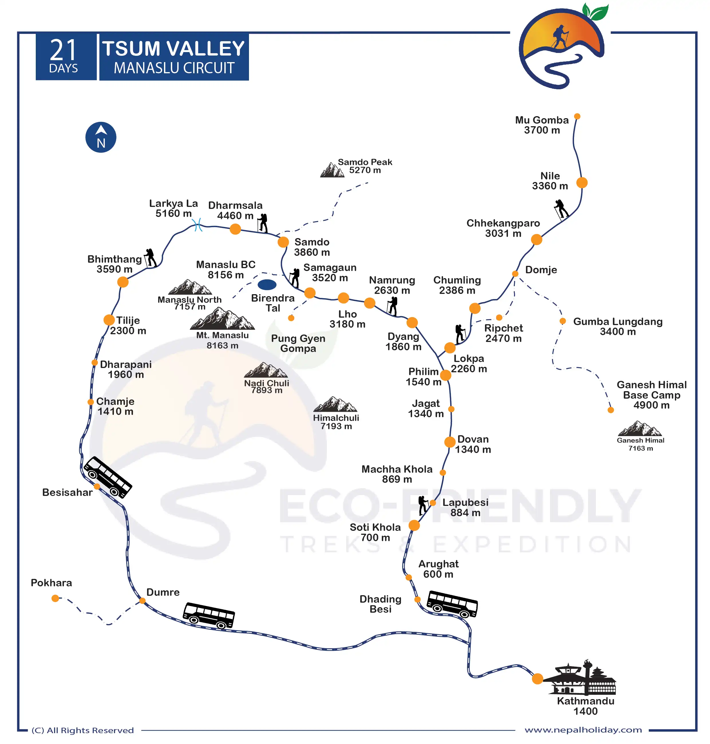
Manaslu-Tsum Valley Trek Route Map
Are you wondering about the map of the Manaslu Tsum Valley Trek? If you click on the infographic image below, you will see the route map for the Manalsu and Tsum Valley Trek. We have included every overnight stay and elevation reference on our map. Click on the infographic image below to find out about the route.
In total, the Manaslu Tsum Valley Trek is 21 days, starting with the scenic drive from Kathmandu to Soti Khola. The total length of the Manaslu Circuit Trek is about 142 miles. However, the distance between the start point and the distance between the days of the itinerary differ. Our trek starts ahead, to Soti Khola, Jagat, Lokpa, Ekle Bhatti, Chhokangparo, and back to Jagat. From there, we will continue towards Namrung, Sama Gaun, Dharmasala, and Larkey La Pass. We descend to Bimthang, Dharapani, Besisahar, and then Kathmandu.
Is the Manaslu Tsum Valley Trek Difficult?
The Manaslu Tsum Valley Trek is a demanding trek considered among the toughest in Nepal. This trip takes you to a remote village in the Himalayas near the Tibet border. This trail can be challenging for experienced and inexperienced trekkers due to its high passes and steepness.
As you climb, fewer trees will shelter you from the snow, sun, and wind. Regardless of your degree of experience or the number of times you have made this walk, you still risk getting altitude sickness if you do not take the necessary precautions.
How difficult the Manaslu Circuit Trek is will depend greatly on your fitness. Give yourself enough time to prepare before trekking because it is a long journey. To overcome the difficult terrain of the Manaslu Tsum Valley Trek, you must be physically strong. So, we recommend starting with exercises at least 3 months before the trek.
Manaslu Tsum Valley Trek Permit
For the Manaslu Tsum Valley trek, you need to have three special permits; Manaslu Restricted Permit Fee, Manaslu Conservation Area Entry Fee, and the Annapurna Conservation Area Entry Fee (ACAP).
You cannot trek up Manaslu without a permit. This fee is necessary to ensure the future preservation of the region’s unique culture and ecosystem. MCAP and ACAP are also essential for the Manaslu Tsum Valley trip.
For more info; please visit: Trekking Route and Permit Fee
Note: In most circumstances, you will be required to present passport-sized images and a copy of your passport while filling out the official documentation. Therefore, you must bring at least 8–10 pictures in passport size. We will fulfill all legal procedures and obtain all necessary permits for your journey.
Accommodation on Manaslu Tsum Valley Trek
The neighborhood residents run modest lodgings along the Manaslu and Tsum valleys. The tea houses were previously small wooden cottages with a room divided by wooden blocks. The rooms are basic, with twin sharing and shared bathrooms, or they may be separate in some places. Although camping on the Manaslu Tsum Valley trek is possible, most trekkers prefer to be accommodated in a teahouse.
The beds usually have a mattress pad, blanket, and pillow, and they are cozy. You will also be provided with a blanket, but you can take a sleeping bag with you as the night will be colder. The rooms are usually cheap, but you have to pay an extra charge for a hot shower, Wi-Fi, and electricity.
A central dining area with a heating system is always present and keeps the hotel warm. One can spend time with loved ones, unwind, chat with fellow trekkers, exchange emotions, and have coffee or tea in the evening.
Please be informed that we will provide you with accommodations only during the trek. While staying in Kathmandu, you should pay for your hotel yourself. There are numerous options of hotels available, and we want you to stay wherever you feel comfortable. We are always available if you need any suggestions on hotels.
Related Article: Manaslu Circuit Trek Accommodations
Food and water on Manaslu Tsum Valley Trek
Dhindo, rice, roti, and potatoes are the most significant among the Himalayas’ traditional Manaslu Tsum Valley Trek foods. The green vegetable Gundruk is fermented and frequently served as a soup. On the other hand, Dhindo is a porridge made from barley, corn, millet, or buckwheat. This meal is recognized to be more energizing and long-lasting.
Protein, mineral, and carbohydrate-rich foods and beverages give you the energy to walk on high-altitude treks like the Manaslu Tsum Valley Trek. To make the travel experience more enjoyable, we focus on eating healthy foods and avoiding junk.
Drinking water taps are also available while you are on the trek. You will occasionally encounter natural water resources too. You can also buy mineral water, boiled water, and cold filter water in teahouses. However, we recommend chlorine drops or the SODIS method of purification rather than bottled water.
Please be aware that we will serve you three meals during the trek. The cost doesn’t include meals in Kathmandu. Because of the variety of food options available here, we let you explore breakfast, lunch, and dinner by yourself. We can also manage your food service in Kathmandu upon your special request. For that, please let us know while customizing your trip.
Related Article: Food and Drinks in Manaslu Circuit Trek
Best season to trek Manaslu Tsum Valley
Spring and autumn are ideal for trekking on the Manaslu Tsum Valley Trek. For the autumn, ideally, mid-October and mid-December are best for the trek. The best time of spring is from the middle of March through the first week of June.
The most awesome things you encounter during this time are clear, pleasant weather, a lovely atmosphere, and much happiness. The views of the snow-covered peaks above the lush valleys and ranges will be stunning.
Altitude Sickness & Acclimatization of Manaslu Tsum Valley Trek
The trails above 4000m are challenging, regardless of how many times you have hiked this or the same level trail. While trekking, acclimatization is crucial, as is regular hydration. It involves using a variety of strategies to adapt to the changing environment.
There is less oxygen and air pressure in the atmosphere of the high-altitude region above 3000 m. It would help to avoid alcoholic beverages and caffeine while trekking, as they are the primary causes of dehydration. Drink water frequently to hydrate your body.
Altitude sickness is a severe condition; if anyone ignores it, the case can worsen and cause death. Most of the best treks in Nepal are at the highest altitudes. So, before you trek, you must know about the altitude sickness in Manaslu Tsum Valley Trek: what it is and how to avoid it.
We request that you start exercising your body before you go high-altitude trekking. Join a gym, go hiking on rough terrain, and keep your diet in check. Following this helps you a lot during the trek.
Manaslu Tsum Valley Trek Packing Suggestions
Please properly pack your luggage for the porter (each of you weighs 15kg; for two of you, a porter is arranged). You will leave the rest of your luggage behind at your hotel until the end of this holiday. Below is a loosely advised Manaslu Tsum Valley Trek packing list that might help you on your trek:
- Appropriate clothing (3 sets)
- Woolen sweater or jacket
- Thermal inner wear
- Wide-brimmed hat
- Woolen cap and scarf
- Thick woolen gloves
- Waterproof gloves
- Sport Sandals
- Woolen socks (2 pairs)
- Waterproof (not water-resistant) shoes with a good tread or grip
- Rain-proof pants and jacket with hood
- A lock for the duffle bag
- Backpack with waterproof cover
- Sleeping bag suitable for temperatures around 0°C (optional)
- Down jacket with hood
- Camera (optional) (video camera is not permitted by authority)
Other essential items:
- Personal clothing
- Toiletries
- Small thermos for hot beverages
- Water bottle (1 liter)
- Sunscreen lotion (50 SPF or more)
- Castor oil (50 ml) to lubricate the nostrils at high altitude
- Ziplock bags for clothing
- Quick-dry Towel (not a regular one)
- Toilet paper
- Wet wipes
- Sunglasses
- Snacks: chocolates, biscuits, nuts, etc.
- Hand sanitizer
- Powerful flashlight or headlamp (with extra batteries)
Medical Kit
Though we arrange basic medical kits for the Manaslu Tsum Valley Trek, they are very general and may not be adequate based on conditional necessity. Personal medical equipment with electrolyte packs, pain killers, muscle relaxant cream, band-aids, knee caps, medicines for fever, common cold, headache, nausea, vomiting, diarrhea, indigestion, and any other personal medication is necessary from your side.
Communication in Manaslu Tsum Valley Trek
The Manaslu Tsum Valley Trek itinerary encounters different landscapes. Even in this age of highly modern information and communication technologies (ICT), the landscapes are challenging for development in remote areas.
Most of the villages along the Manaslu Tsum Valley Trek now have access to mobile phones and telephone services. Internet access is available in most tea shops, usually for a fee per hour. Wi-Fi is available in Lho, Samagaun, and a few nearby settlements. However, bad weather, such as heavy snowfall and rain, occasionally interferes with services.
Most asked questions
FAQs about Manaslu Tsum Valley Trek
People have known for a long time that living in the Himalayas helps them feel joyfully whole. For a long time, being in the mountains, woods, or any other natural place has been linked to feeling complete inside.
The Himalayas have the power to bring people together and make them happy. Do not discount your personal interests. They may be so interesting that they motivate you to reach your goals and grow as a person.
Because of this, we think that the Manaslu Tsum Valley Trek is more than just a trip. How you experience it, though, will depend on how curious and aware you are.
The Larkya ka La Pass is the highest point of the Manaslu Tsum Valley Trek, at 5106m.
If you want to visit the Manaslu region for any reason, you must first obtain permission to enter. To visit a protected region designated by the government for trekking, a particular trek permission is required. Manaslu Restricted Permit Fee, Manaslu Conservation Area Entry Fee, and Annapurna Conservation Area (ACAP) Entry Fee are required.
The permit is for your protection while entering the conservation area. This permit fee is also utilized to improve the national park.
Our itinerary is one of the best for all, so there may not be a reduced choice if you are a beginner in high altitudes. Reducing the itinerary may lead to a lack of time to adjust to changes in the environment, humidity, or pH, which may lead to high altitude sickness and other problems. Your body needs time to produce more red blood cells to counteract the lower oxygen saturation in blood at high altitudes.
But if you are willing to spend more time in the Manaslu Tsum Valley Himalayas, we have the best other options to extend the days and customize your itinerary per your demand. Feel free to get in touch with us, and our team shall provide you with your dream package under your priorities and our guidance.
In Nepal, it is mandatory to hire at minimum one government-licensed guide from a local trekking service. There must be at least two members in each group (not including the guide or porter).
Additionally, if you experience high altitude sickness, your trekking guide will immediately monitor your symptoms. They will help you at every stage because they are familiar with the surroundings and the wildlife. If you are an independent trekker, it is not necessary to bring a guide along for this trek, but a guide will be helpful for a hassle-free vacation.
Your battery is more likely to drain quickly in a cold environment. So it would be best if you recharge your battery from time to time. You can charge your battery in the lower part of the trail where you spend your night, but as you reach higher, there is a low chance to recharge your battery. You must pay an additional fee if a charging service is available because the lodge uses solar energy to run the electricity.
However, you can bring a spare battery for your camera and other devices, so you would not need to worry about charging it frequently. There might be a power cut or low voltage, so it will be best to carry the portable power bank.
As traveling through high-altitude regions, assessing your health and fitness is crucial. Every trekker’s experience is made safer and more comfortable thanks to it.
Due to our conviction that children benefit from nature in various ways, we are pleased to welcome you and your family to the Manaslu Tsum Valley Trek. With a professional guide, the trek can be done smoothly. However, we would not suggest bringing kids who are too young (less than 8 years old) to go hiking at high altitudes.
For at least three months, prepare your kids for this trek by having them practice easy exercises and breathing techniques. Please let us know if you require a kid carry service during the inquiry process.
Before starting your journey to Manaslu Tsum Valley Trek, we want to inform you that we have already paid for several things on your behalf: your; permit, taxes, and others. Please also be aware that we must compensate our porters and guides even if you cancel or choose not to finish the trip because of their commitment to serving you.
Specific fees apply if you desire to cancel your reserved trips. Behind that, we welcome you to shift your trip days to Manaslu Tsum Valley trekking or the package itself. We may charge a specific amount of money if you wish to reschedule/cancel the booking date. Both parties will benefit if you inform us as soon as possible. Please go through our terms and conditions to clarify the refund process.
In case of trekkers finish their journey sooner than expected or decide to terminate it early for any reason, kindly be aware that we do not grant refunds for any portion of the trek that is not used. This also totally depends on the circumstances, but we request that you not expect a refund for the above-mentioned reasons.
If the visitor does not reach our target within the period mentioned, the Manaslu Tsum Valley Treks fixed departure package will be shifted to a customized package. The targeted and fulfilled travelers are updated in the date and price sections. We will surely let you know about every change.
Due to the party size, we offer you a very affordable price on a fixed departure. The Manaslu Tsum Valley Trekking program will be revised if the group criteria are not met, which will change the price, including terms and conditions.
Note: We do not add or deduct the activities on the program of fixed departure. Please get in touch with us for the unique customized package if you create your itinerary rather than taking part in a fixed departure. Our team will happily assist you in your journey to Manaslu Tsum Valley with their experienced advice and recommendations.
We highly suggest you engage in physical activities three months before the trip to prepare yourself physically and mentally. Additionally, we offer the Soldhunga Hike as part of our quick acclimation training trip. You can utilize this hike as a very small preview of what to expect on your main journey through the existence of the central Himalayas.
We request that you ask our ground team in Kathmandu for assistance in arranging day tours around the city. If you still have time a few days or a week after the trek, we can also set up one of the following quick relaxation trips. Feel free to pick the one you think will best suit your interests.
- Pokhara
- Lumbini
- Ghandruk
- Chitwan Safari
These additional vacation days were planned with the idea that you would want to relax after a challenging and long trek rather than go on hiking again. Please let us know if there are any other destinations you would prefer over these.
Reviews on Manaslu Tsum Valley Trek
![]()
![]()
![]()
![]()
![]()
Based on 3
Reviews

Hatta Sachiyuki
Kyoto, Japan
Best experince with Nepal Holiday!
The airport pickup was very welcoming and the hotel transfer was quick too. We hotel in Kathmandu we are staying in was the International Guest House. The hotel was average but the service was great.
Nepal Holiday provided us with the best trip guide to make our trip successful. I would like to recommend the outdoor service of Nepal Holiday to other friends.
Miyagawa Kiyoaki
Kyoto, Japan
Best arrangement for our trek!
The service provided by Eco-Friendly treks was very good. All the crew members are good and polite. Our guide was also very informative and helpful in the trial.
Sakamoto Kimikazu
Kyoto, Japan
Successfully done the trek with the help of guide and all hard working staffs
I like to recommend our friends to take trekking with Eco-friendly support. We really enjoyed the wonderful exciting and adventurous trekking under the best support of the guide and all the hard-working staff.
© Copyright 2024 Eco-friendly Treks. Website Developed by: AVIVA