


Trip Introduction
Overview of Tsum Valley Trek
Located east of Manaslu, near the border with Tibet, the Tsum Valley Trek is home to the Tsumbas, a people who trace their ancestry back to the Tibetan people who first settled the region. The Tsum Valley Trek delivers heaven for those who are interested in Tibetan culture, nature, and the Himalayas on a pilgrimage-like trip into this undiscovered valley.
The Tsum Valley Trek is a fantastic vacation spot for those who find comfort in the presence of unspoiled natural recreation. Ancient settlements and Tibetan Buddhist monasteries still stand remarkably unchanged. After five to eight hours of walking every day, the trip concludes four thousand meters above the valley’s greatest monastery, Mu Gompa.
Because the Tsum Valley has not yet been affected by modern developments and still represents its beautiful ancient tradition, you will frequently encounter local “homestays” along your trek route. During our frequent stays in homestays, you will meet the friendliest and most generous people you will ever meet on this trip.
In addition, the Tsum Valley trail leads across pine forests, along roaring rivers with cascading waterfalls and spectacular suspension bridges, unique villages, and a number of gompas, monasteries, mani walls, and stupas, including Milarepa’s Cave.
You will have a view of mountain ranges such as Himalchuli (7,893 meters), Ganesh Himal (7,140 meters), Manaslu (8,163 meters), Churke Himal, and the Poshyop Glacier. Following your interests, we will direct you on a Tsum Valley trek that will fulfill your need for recreation. Our Tsum Valley package is meant as a recommendation, so if you want to make any adjustments, feel free to get in touch with us.
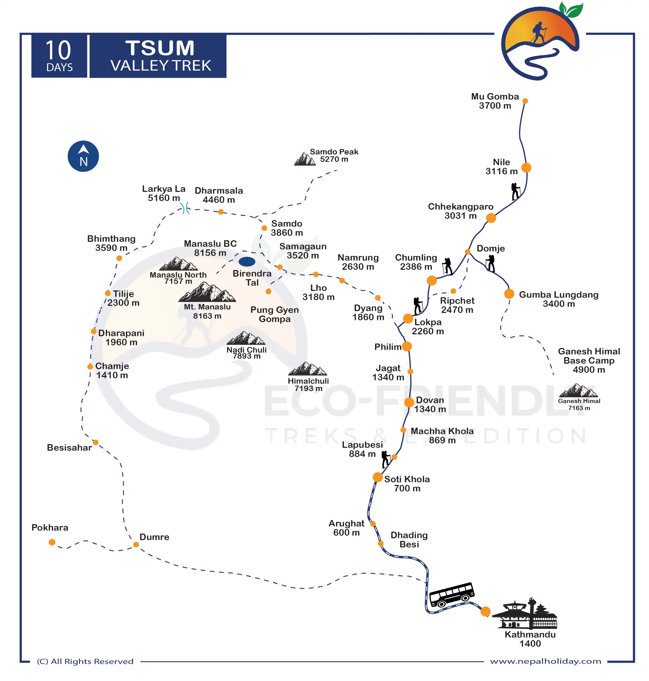
Tsum Valley Trek Route Map
The Tsum Valley Trek distance is 10 days, starting with the scenic drive from Kathmandu to Machha Khola. The total length of the Tsum Valley trek is about 78.29 miles, i.e., 126 kilometers. However, the distance between the start point and the distance between the days of the itinerary differs. Our trek starts ahead to Machha Khola, Jagat, Chumling, Chhekampar, Ekali Bhatti, and finally to Mu Gompa. We then descend from the same route to reach Kathmandu. On the map, you will also see the extension route. Upon your interest, we can also extend the route to Manaslu Circuit for more exciting views.
Seeking an explanation of the Tsum Valley trail’s layout? In order to learn more about the route, please click on the infographic picture that follows.
Is Tsum Valley Trek Difficult?
The difficulty level of Tsum Valley is moderate to adventurous because of the high altitude, reaching above 3700m. The trail of Tsum Valley is not that difficult, but because of the high altitude and some steep descent, Tsum Valley is graded as a moderate to strenuous trek.
This trek takes you to a hidden, remote village in the Himalayan region near the Tibet border. You will pass through numerous steep trails and vertical descents on the trail. During this trek, you will experience winding ups, starting with some areas of a gradual climb and a few sections of a steep climb. Returning from the top is somehow easy because of the downhill, low altitude, and warm sub-tropical area.
Moreover, trek difficulty will also depend on your physical fitness, backpack, trail condition, gear, food choice, acclimatization process, and so on. So, make a proper plan for all those before trekking to Tsum Valley.
Tsum Valley Trek Permit
For the Tsum Valley trek, you need to obtain a restricted area permit and a Manaslu Conservation Area Entry Pass. Entry permits are only valid for one entry, are nonrefundable, and cannot be transferred.
For more info; please visit: Trekking Route and Permit Fee
Note: In most cases, while preparing official paperwork, you will be required to submit passport-size photos and a copy of your passport. So, be sure to bring at least 8–10 passport-size photos. We will complete all legal requirements and acquire all required permits for your trip.
Itinerary of Tsum Valley Trek
Your trek to Tsum Valley begins from Kathmandu. We will start driving a direct bus from Gongabu Bus Park either at 6 or 8 AM. After 7 hours of driving through a dusty and bumpy road will take you to Machha Khola.
Although the road is quite dusty, you will catch the best green landscape, fields, and fast-flowing rivers from your window. During the ride, the bus will stop for short break and meals someplace.
After the early morning breakfast at your teahouse hotel, we will start our walk of the day. The initial trail is quite rocky and uneven. The stunning countryside view, green hills, and rivers will keep you engaged through the trail.
During the trek, you will pass through Sal forests, waterfalls, towering cliffs, and a few settlements of Gurung and Ghale of the region. Following the river trail, we will pass through several ups and downs to reach Jagat.
The next day, you will head towards Salleri and descend to Sirdibas. At this point, you will start to notice several Buddhist prayer flags and gompas. After some additional walking, you will finally reach Phillim. You will have to verify your permit here and then continue along the western bank of the river.
As you walk ahead, pass through the forests of rhododendron, Himalayan pine, and overhanging ricks on towering peaks. These highlights during the trek will beautify your moments. On walking further you will cross the Siyar Khola bridge and the trail separates to Tsum valley on the right.
After Lokpa, we will then get down to Lungwa river. The trails will get narrow and a little confusing for a short period of time. As we walk further, the trail incline slightly to reach Gumlung. Ahead, the trail will be easier until you reach the beautiful village of Chumling.
After early morning breakfast we will start our walk appreciating the glorious vies of Ganesh Himal as our backdrop. As we walk ahead, we will cross the Shiar river and a small Tibetan monastery along the path. You will notice a stone Tibetan influence in this valley. Today’s walk ends after you will reach Chhekampari.
As we walk further with tributaries still acting as our guide, the trail goes way deeper and higher into the valley. The trail follows the ancient trade route to Tibet as we pass through the chorten, mani walls, monasteries, stupas, and nunneries. This reminds us of the close cultural and historical bonds.
You will also get a chance to visit the Burji village and Milarepa Cave. The cave sits on the slope of Mt. Langju. After crossing the southeast bank of the Siyar river we will reach Phurbe. After some hours of walking, you will reach Pangdun. You will also notice numerous gompas and large prayer wheels until reaching the Nile.
The trail will take you near the boarder of Tibet. From the Nile, you will head west side to reach Mu Gompa. It will not take much time to reach Mu Gompa from the Nile.
Mu Gompa is the highest point in this whole trek. You will reach up to 3700 meters above sea level and the gompa is about 77 yrs old. You will get an opportunity to view the mesmerizing view of the surrounding mountains and the Lungdang glacier.
You will then follow the same route getting back to Siyar river towards Milarepa’s cave. After additional descent, you will then reach Burji village. From there we will then reach Lama village and then Chhekampar.
After the early morning breakfast, we will continue our trek back to lower Tsum Valley. You will then descend ahead to Chumling then Lokpa and finally to Eklei Bhatti.
Further, we will walk ahead to Philim village where you will be able to witness an amazing view of Mt. Shangrila. You will cross several ups and downs to reach Jagat village. You will then pass through a narrow route towards Thari Khola today. The route is comparatively easy and leads you to the Khorlabesi. You will then cross to suspension bridge before you reach Khorlabesi.
You will then walk keeping the Budi Gandaki River on your side to reach Khanibesi. The trails get a bit rocky here and you will also cross numerous waterfalls, cliffs, and terrace fields. After some hours of additional walking, you will reach Lapu Besi which is also an attractive Gurung village.
After the early morning breakfast, we will head toward the Khursane and cross the suspension bridge over Soti Khola. After then, we will follow the trail to Machha Khola which is around 14km away from Soti Khola.
The 11 days of the Tsum Valley Trekking itinerary is only for guidelines. You can customize the trek according to your own taste. However, this does not apply to fixed departures. Fixed departures orient as the team suggests.
The above trekking hours are also estimated for general ideas only. The itinerary also depends upon traffic and weather conditions on your activity date.
Includes/Excludes
What's Included?
- Bus Fare during the trek
- Permit Cards Expenses
- Experienced Himalayan trek guide for 9 days
- One porter for two of you for trekking for seven days (prepare to give max. 15 kgs’ luggage from each of you so that it will not exceed 30 kg. for your porter)
- Basic yet comfortable accommodation for 9 nights on a twin-sharing basis during the trekking as per itinerary.
- Staff insurance
- 9 x set breakfasts, 9 x set lunches, and 9 x set dinners while on the trek
- Purified drinking water during the entire trekking as per itinerary
- General first aid medicine kit
- Complimentary T-shirt
- Duffle bag during the trek
What's Excluded?
- Accommodation in Kathmandu since there are many possibilities available.
- Personnel expenses of any kind
- Any Travel Insurance
- Any additional cost due to natural calamity and unforeseen circumstances.
- Tips for any staff and guide
- Anything that is not listed in the “PRICE INCLUDES” section above
Essential Information - Tsum Valley Trek
Accommodation on Tsum Valley Trek
Staying in lodges and teahouses is a standard part of the Tsum Valley Trek. Lodging options include lodges at a more accessible altitude. Most teahouses are located along the trail’s higher section. Most rooms have two single beds and share a bathroom.
A single room/homestay can be customized for you if you would like, although it may cost extra. Not all hotels provide rooms that can accommodate a single traveler. It is nice enough there that you could stay for two nights without any problems.
Food on Tsum Valley Trek
In a similar way, the meals are provided according to the menu that is available in the teahouse or lodge. The restaurant serves traditional Nepalese meals in addition to Tibetan foods on the menu. There is a possibility that you will also be offered a selection of other cuisines, such as Indian and Continental.
Best season to trek Tsum Valley
The Manaslu Tsum Valley Trek is typically done in the autumn (September to November) or spring (March to May), which is when you have a much better chance of getting to see the mountains in crystal clear conditions and when you can also experience the greenery in the lower regions of the trail, particularly during the spring.
Altitude Sickness & Acclimatization of Tsum Valley Trek
Due to the extreme altitude changes in the region, you will need to take your time walking. The risk of experiencing the effects of high altitude during the Tsum Valley Trek is not high. Altitude sickness is more common at Tsum Valley in Nepal if you are used to living at a lower elevation. Because of the high altitude, your body’s ability to adjust to the different oxygen and pressure levels may be compromised.
In addition to this, you should participate in some physical activities before the hike begins, and you should make sure to stay hydrated throughout the entire hike. This is of great assistance to you during the trek in easy walking, and in altitude sickness as well.
Tsum Valley Trek Packing Suggestions
Please properly pack your luggage for the porter (each of you 15kg, for two of you, a porter is arranged). You will leave the rest of your luggage behind at your hotel until the end of this holiday. Below is a loosely advised Tsum Valley Trek packing list that might help you in your trek:
- Appropriate clothing (2 sets)
- Woolen sweater or jacket
- Thermal inner wear
- Wide-brimmed hat
- Woolen cap and scarf
- Gloves
- Sport Sandals
- Woolen socks (2 pairs)
- Waterproof (not water-resistant) shoes with a good tread/grip
- Rain-proof pants and jacket with hood
- A lock for the duffle bag
- Backpack with waterproof cover
- Sleeping bag suitable for temperatures around 0°C (1 – optional)
- Down jacket with hood
- Camera (optional) (video camera is not permitted by authority)
Other essential items:
- Personal clothing
- Toiletries
- Small thermos for hot beverages
- Water bottle (1 liter)
- Sunscreen lotion (50 SPF or more)
- Castor oil (50 ml) to lubricate the nostrils at high altitude
- Ziplock bags for clothing
- Quick-dry Towel (not a regular one)
- Toilet paper
- Wet wipes
- Sunglasses
- Snacks – chocolates, biscuits, nuts, etc.
- Hand sanitizer
- Powerful flashlight or headlamp (with extra batteries)
Medical Kit
Although we give basic medical kits for Tsum Valley Trekking, they may not be adequate for the actual needs. Your own medical equipment must have electrolyte packs, pain relievers, muscle relaxant cream, bandages, a knee cap, and pills for fever, the common cold, headache, nausea, vomiting, diarrhea, and indigestion, in addition to any other personal medications.
Communication in Tsum Valley Trek
Most trekking routes in Nepal feature diverse landscapes. Even in this day of highly advanced information and communication technologies (ICT), the terrain makes it difficult to develop in remote areas. Insufficient technological progress is a contributing element.
Due to the need for communication in such a setting, guides are supplied with mobile devices that connect to a networked site. There are also telephones available in the lodges for a charge. On Tsum Valley trek route, Wi-Fi may be available in a small number of locations.
Most asked questions
FAQs about Tsum Valley Trek
In the Himalayas existence like Tsum Valley or any natural presence, people have understood for decades that they can find a sense of happy fullness within themselves. Being in the great outdoors, be it the mountains, the forests, or anywhere else in nature, has long been connected with finding personal contentment.
The Himalayas are a place where people may overcome their differences and have recreation together. You should never overlook the importance of your own passions and hobbies since they may end up being the sparks that enable you to realize your full potential and develop into a fully realized individual.
We think the Tsum Valley Treks are worth more than a casual glance, but your level of curiosity and observance will shape your actual experience.
3,700m / 11,026ft. The Mu Gompa is the highest point in the Tsum Valley Trek, and is reached by taking a short trek from the Nile all along west bank of the valley near to the Tibetan border.
For the Tsum Valley trek, you need a Manaslu Conservation Area Project (MCAP) and Restricted Area Permit because the trail is situated in the Manaslu region. The permit fees help develop and protect the 1,663-square-kilometer Manaslu conservation area, which is covered by the area.
We have a customized package for this purpose, which lets you change the packages we have made. You can look into your options and change them connecting with us.
Also, our schedule is one of the best for everyone, so you may not have options to reduce the days if you are new to high altitudes. If the schedule is shortened, there might not be enough time to adjust to changes in the environment, humidity, or pH, which could cause high altitude sickness and other problems. Your body needs time to make more red blood cells to make up for the fact that blood at high altitudes has less oxygen in it.
But if you want to spend more time in the Himalayas, we can give you the most options to extend your days and make your trip fit your needs. Feel free to get in touch with us; our team will put together your dream package based on your needs and preferences.
If you are on a package tour with us, you should indeed travel to Tsum Valley Trek with the guide. When you travel with a local agency such as ours, we will prioritize your safety. If you journey with a guide, you will have more options for food and lodging, and the language barrier will be reduced. They will always be available to assist you with permits, domestic flight arrangements, and local porters, as well as the duration of your journey.
In addition, if you develop altitude sickness, your guide will monitor your symptoms quickly. They will assist you at every level due to their familiarity with the environment and wildlife.
In a cold environment, your battery may drain more rapidly. Therefore, it is recommended that you recharge your battery frequently. You can recharge your battery on the bottom portion of the route where you spend the night, but as you ascend, the likelihood of doing so diminishes.
However, we suggest you to bring spare battery for your camera and other devices, so you would not need to worry about charging it frequently. There might be a power cut or low voltage, hence, it is recommended to take the portable power bank.
As you travel through high-altitude locations, it is essential to examine your health and fitness. It makes the experience of every trekker safer and more comfortable.
Due to our conviction that children benefit from nature in various ways, we are pleased to welcome you and your family to the Tsum Valley Trek. With a professional guide, the trek can be done smoothly. However, we would not suggest bringing kids who are too young (less than five years old) to go hiking at high altitudes.
Prepare your children for this trip by helping them with practicing simple exercises and breathing methods for at least one month. During the inquiry process, please indicate if you need a child-carrying service.
Several charges, including permits, taxes, and others, must be paid in full prior to the start of the journey. Please be advised that even if you decide not to complete the entire journey, we must compensate our guides and porters for their time. It is extremely challenging for us to offer refunds for any reason.
Occasionally, trekkers complete Tsum Valley earlier than intended or decide to end their journey early for personal or health reasons. Please be advised that we do not offer refunds for unused portions of the expedition. This is also dependent on the circumstances, however, we ask that you not expect a return for the reasons stated previously.
Days before your arrival date to the trip destination and cancellation fees
We highly suggest you engage in physical activities three months before the trip. It helps you to prepare physically and mentally during the trek. Additionally, we offer the Soldhunga Hike as part of our quick acclimation trip. You can utilize this hike as a very tiny preview of what to expect on your main journey in the existence of the central Himalayas.
Please contact our ground staff in Kathmandu for assistance booking city day trips. If you have a few additional days or a week after the journey, we can organize one of the following short trips for your pleasure. Choose the option that you believe best suits your interests.
- Pokhara
- Lumbini
- Ghandruk
- Chitwan Safari
All these extra vacation days were added because it was thought that after a challenging and long trek, you would want to rest rather than hike again. Please let us know if you would rather go somewhere else than these places.
Reviews on Tsum Valley Trek
Be first to post a review in this trip.
© Copyright 2024 Eco-friendly Treks. Website Developed by: AVIVA