
Trip Introduction
Overview of Langtang Gosaikunda Trek
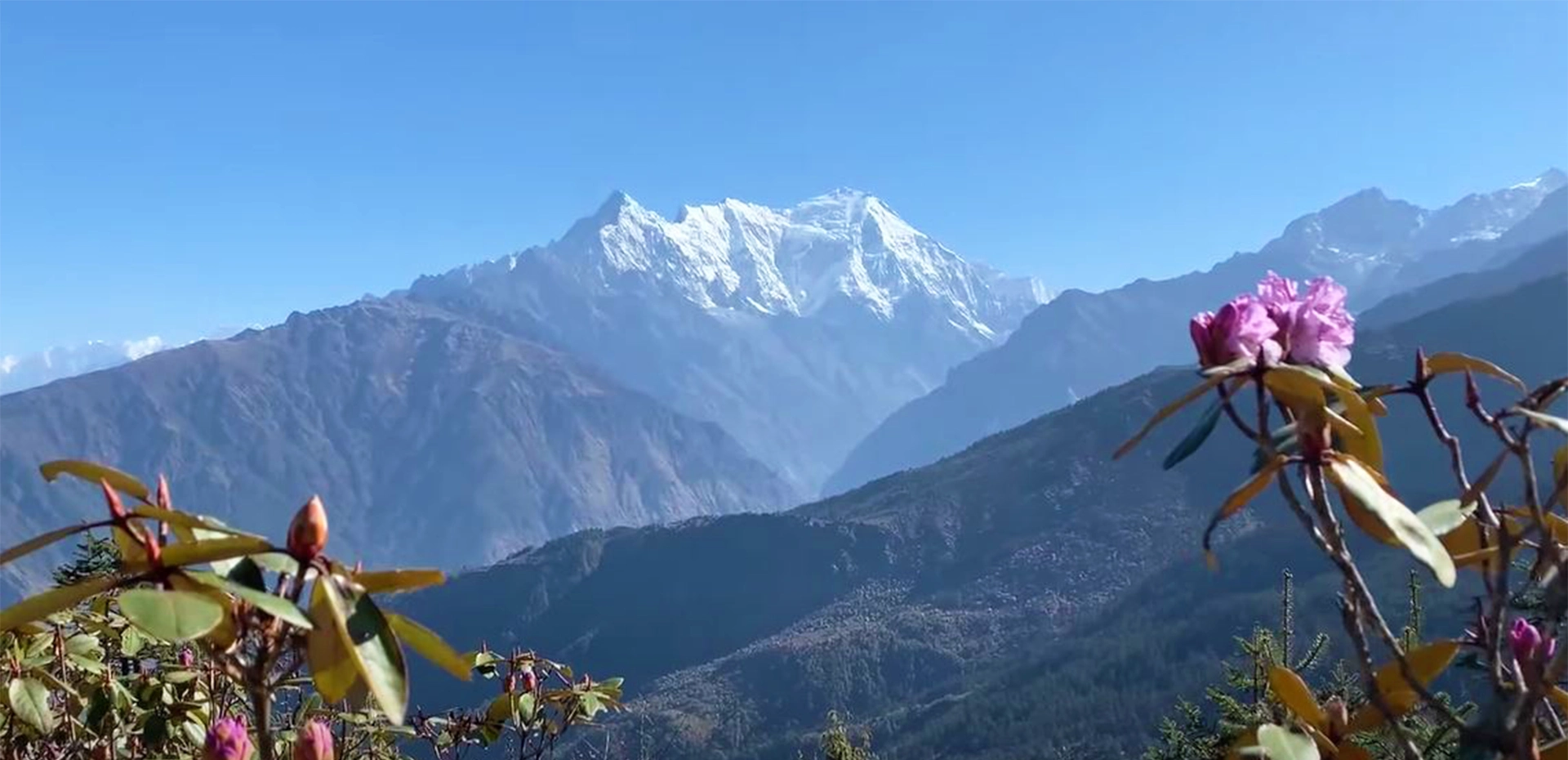
Walking on the Langtang Gosaikunda Trek offers beautiful paths in the Langtang region that are less crowded. The trail offers spectacular views of the Himalayas and the surrounding area, which helps you get insight into a better understanding of yourself. The pure surroundings of the Langtang Gosaikunda path including clean air, water, and pure energy—all unite to enhance your experience of being in the present.
During your walk, you will be delighted to gaze at the Langtang region’s other snow-capped summits, including Langtang Lirung (7,345m), Gang Chenpo (6,388m), Naya Kanga (5,846m), Dorje Lakpa (6,966m), Kimsung (6,781m), Yansa Tsenji (6,575 m), and natural scenery throughout the trail.
Additionally, rich culture, traditions, and a unique way of life for the people there add extra sparkles to your journey that encourage “being in the state of wholeness.” The warm-hearted local communities’ customs, language, clothing, and cuisine of the Langtang Gosaikunda trek are also the major highlights of the trip, which are all wholly their own. The majority of the people living in these villages are Tamang. Spending time with these communities is a great way to connect with new cultures and traditions and celebrate each other’s differences and similarities.
Understanding different cultures enriches our lives and enables more profound connections with those around us, even in our regular lives.
The trail will have several challenging uphill parts and must issue a reverse challenge to Langtang Gosaikunda. On top of that, you may need various forms of guidance during or before your trip. We, the Nepal holiday team, assure you that we will be with you during your trip and before that if you need assistance. We guide you to Langtang Gosaikunda trekking based on your desire to spend time in the Himalayas.
Amidst all this, prepare yourself for the Langtang Gosaikunda treks, which have the great possibility of being in a state of an increased level of joyful wholeness.
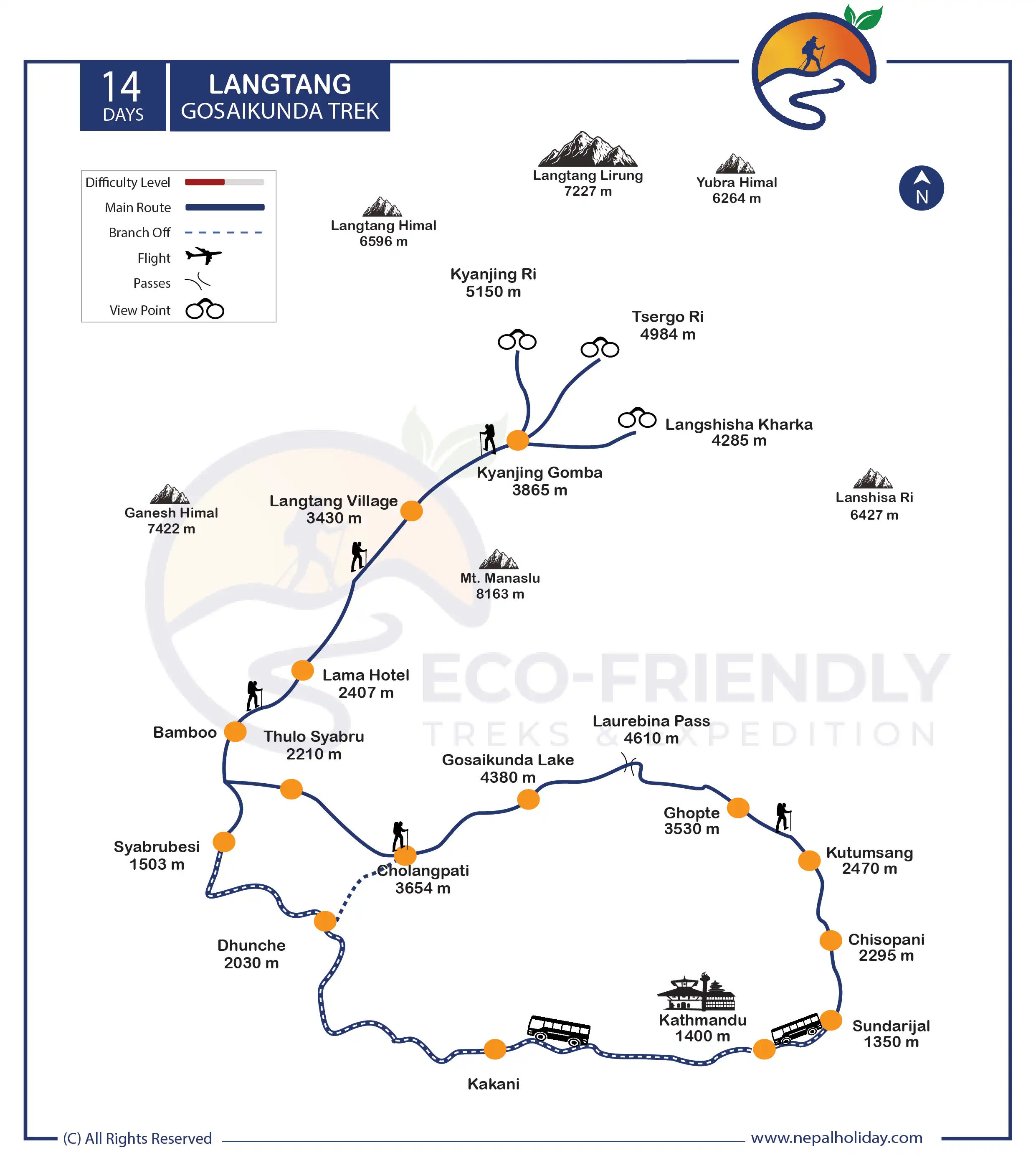
Langtang Gosaikunda Trek Route Map
We present you with an up-to-date and high-quality Langtang Gosainkunda trek map. You will get a tentative description of the entire trekking route to the Langtang Valley and Gosaikunda Lake. We have included every overnight stay for the Langtang and Gosaikunda Trek on our map. Click the infographic image below to learn about the route.
Your journey begins as you start your drive from Kathmandu to Syabrubesi. Starting your trek from Syabrubesi, the trek ends at Sundarijal, where you will visit Kathmandu by local bus. You can also look at our detailed itinerary to learn more about the destination.
Is Langtang Gosaikunda Trek Difficult?
The hike from Langtang to Gosaikunda is moderately difficult. The difficulty level of your hike depends on factors such as the type of route you take, the season you choose to visit the destination, the weather, and your physical fitness.
Moreover, the Langtang Gosaikunda trekking is a 14-day adventure. The path you must take is difficult because it is prone to landslides. Since there are not any hospitals in the area, take precautions. These considerations place a moderate level of difficulty on this trek.
The trail is less challenging because it does not involve any difficult climbing. Gosaikunda, at an altitude of 4,380 meters, is the highest point you will reach on this trek. Foreigners love going there because it does not take long to get there and because it is close to Kathmandu, the capital city.
Langtang Gosaikunda Trek Permit
You should be aware that a Langtang Gosaikunda trek requires two separate permits. They are the TIMS card and the entry permit to Langtang National Park.
The permits mentioned above are mandatory documents before beginning any journey in the Langtang region. You will be required to show them at various checkpoints along the way.
The Langtang National Park Permit keeps track of trekkers’ activities within the national park. This permit also contributes to the trekkers’ safety and security. The information will aid authorities in supporting you in an emergency, such as an earthquake or a landslide.
A portion of the revenue is used to conserve and develop the tourism industry in the Langtang region.
Note: When making official documents, you will usually be asked to send a copy of your passport and a passport-sized photo. So bring at least 8–10 photos that fit in a passport. We will get all the permits you need for your trip and handle all the legal paperwork.
Itinerary of Langtang Gosaikunda Trek
After an early morning breakfast, we will start our day with a long, scenic drive to Syarubesi by local bus. You will head towards the northwest side of Kathmandu and witness beautiful scenery – fast-flowing rivers, terraced fields, villages, and snow-capped peaks.
We reach Syabrubesi via Trishuli Bazar and then descend down to Dhunche. The road to Syabrubesi is somehow rough from Trishuli Bazar. After seven to eight hours of driving, you will finally reach Syabrubesi. This town offers much to explore, including hot springs and riverside to relax.
Today is our first day on the trail, as this is our trekking starting point. Today you will walk for around six hours via Pahare hotel, hot Spring, Bamboo, and Rimche to reach Lama Hotel. Today you will gain about 950 meters in altitude.
Walking along the trail will treasure you with several rural settlements, Bamboo, and oak forests, where you might spot rare, local wildlife – including the red panda. You will experience the vibrant culture and lifestyle and explore the vibrant culture and amazing Tamang people.
Ahead, we will pass through a landslide, ascend Bamboo, and gradually descend to Rimche. This village is located on the bank of the Langtang River. As we continue ahead, you will finally reach Lama Hotel.
Today is the second day on the trail, where you will head towards Langtang village. Today you will walk for around 6 hours via Gumnachowk, Ghodatabela, Chyamki, and Langtang villages. From Lama Hotel to Langtang Village, the distance is around 9.1 miles.
During the trek, you will see an astonishing vista of the Himalayan peaks of Langtang Lirung, Ganesh Himal, Naya Kanga, and Dorje Lakpa. This region is the home of endangered animals, so you may have the luck to see them. Today, you will see local Sherpa and Tamang people during your walk.
We will walk alongside the Langtang River while ascending through the dense forest. As we walk forward, the narrow river valley widens out at Ghoda Tabela. We will then cross the east side of the river as we get close to Langtang Valley. Before reaching the village, you will experience the prayer wheels and prayer flags on the way.
Today is the third day you are walking on the trail, and we are heading toward Kyanjin Gompa. The trail will ascend through Mundu, Singdum Yamphy, and Kyanjin Gompa. It takes around 3 to 4 hours of trek to reach Kyanjin Gompa. The distance from Langtang village to Kyanjin Gompa is 3.9 miles.
Today most part of the trail will ascend to reach our destination. The initial part of the trail will take you to the villages, and then we clin the ridge by a large Chorten. We will pass through the beautiful mani wall and cross the stream of Mundi village. After some time, the trail rejoins the fast-flowing river and climbs to the yak pastures of Ymaphu. We then cross another stream on a bridge and climb a moraine to a viewpoint where you see several monasteries. An additional walk will finally take you to the beautiful Kyanjin Gompa.
We will pass through small abandoned villages and meadows during our walk. The wide Langtang valley offers stretching panoramas of the mighty Himalayas. You will be amazed to see the jaw-dropping Himalayan views of Langtang Lirung and Kimshung.
We will stay at Kyanjin Gompa for acclimatization on this day. You will have many side trips during your stay at Kyanjin Gompa. The upper Langtang Valley offers stunning close views of the tall mountains and glaciers. You can climb Kyajo Ri at 5,150m to catch spectacular views of several mountain ranges. You will be able to see Himalayan peaks – including Langtang Lirung (7,227m), Langtang II (6,596m), and Yala peak (5,500m).
If you want, trek to Langshisha Kharka and Tserko Ri (5033). Tserko Ri is the highest altitude you gain during the Langtang and Goasikunda trek. The scene is more beautiful from this viewpoint.
From Kyanjin Gomba, we say goodbye to the upper highlands and start to go down a route. We go back the way we came to get to Kyanjin Gompa. Kyanjin Gompa to Lama Hotel trek distance is 9 miles. Today might be the longest day walk in Langtang valley. It takes 6 to 7 hours to walk from Kyanjin Gompa to Lama Hotel.
We’ll pass by Langtang Village and then Ghora Tabela on the way. We will register at the army post and walk ahead to our destination. Then we’ll start going through the river valley’s thick forests to the Lama Hotel.
The initial part of the trek is gently sloppy until we reach Pahiro. We will reach the bank of the Langtang River and cross some seasonal waterfalls. During the trek, you will pass through a mesmerizing view of Mt. Ganesh and other small peaks. At the end of the day, the trail will get steeper for a while, and we will reach Thulo Syabru village.
Today the trail goes upward through green hills and rhododendron forest. You will also pass through the Langtang National Park’s army checkpoint. After half an hour of walking uphill, we will finally reach the Daragang. The trail will get more accessible from this point and pass through the hemlock and oak forest.
When you get to Shin Gompa, the Cheese Factory is right there. You can go to the cheese factory if you want to. You might also see a rare red panda as you pass through the forest. We will finally get to Cholangpati after walking for a few hours.
As we ascend, the face of Mt. Langtang will be clearer and more beautiful. Today you will notice less vegetation and barren land due to the high altitude. As you walk further, the horizon and beautiful peaks on the west side make your trip memorable. After a few more hours, we will arrive at Laure Binayak. From here, the trail is steep to reach Gosainkunda.
After around two hours of steep walking, you will reach Chorten, and after an additional hour, we will see beautiful waterfalls and lakes. Those Saraswati Kunda and Bhairav Kunda came from the water flowing from Gosainkunda Lake. Hindus and other religions consider this place holy.
You will cross the Laurebina La High Pass today to get to the beautiful area of Helambu. The northern shore is steeper as we get closer to the Laurebina La Pass. Before you get to this pass, you’ll walk by at least three small lakes.
A stone stupa and prayer flags mark the Laurebina La Pass. The Langtang Trek’s highest point is at this pass. We then go down to High Camp through a wide valley (4240 m). The path to Phedi is then steeper and has more rocks. Then we go down until we reach a footbridge over a stream. From Phedi to Ghopte is a hard journey with long climbs.
We start our hike by walking through a juniper, rhododendron, and pine forest. Before we get to Tharepati, which is in the highlands, the trail is remote and unpolluted. From Tharepati, the path goes down the western slope of the ridge gently. After walking, we’ll come to a large meadow with the ruins of shepherd’s huts.
You can see Gangchempo and Dorje Lakpa peaks from the path. Then we go down more steeply through a forest until we reach Magin Goth (3265m). We’ll walk past Kuala Bhanjyang (3335m) and down to the village of Kutumsang after a short distance (2470m).
We will go up for a while from Kutumsang and then go down to Gul Bhanjyang Village. Then we climb until we reach a dusty, wide road at Thorong Danda. We go to Chipping village on a steep, rocky path.
Then we slowly go down until we reach Pati Bhanjyang, a village at 1760m that is between Chipping and Chisopani. We walked for half an hour to get to Chisopani, known for its amazing views of many mountains.
Just a 4 hours walking distance from Chisopani, we find the entrance to Shivapuri National Park. We’ll head down the hill on a broad road, then back up it on a paved path. By the time we reach Sundarijal. We also see a few water reservoirs and enormous water pipes. By the time we reach Sundarijal.
Includes/Excludes
What's Included?
- Kathmandu to Syabrubesi and Sundarijal back to Kathmandu local bus fare during the trek
- Langtang National Park entry permit fee
- Trekkers Information Management System (TIMS) card fee
- Experienced Himalayan trek guide for 13 days
- One porter for two of you for trekking for 12 days (prepare to give max. 15 kgs’ luggage from each of you so that it will not exceed 30 kg. for your porter)
- Basic yet comfortable accommodation for 12 nights on a twin-sharing basis during the trekking as per itinerary.
- Staff insurance
- 12 x set breakfast, 13 x set lunch and 12 x set dinner while on the trek
- Purified drinking water during the entire trekking as per itinerary
- General first aid medicine kit
- Complimentary T-shirt
- Duffle bag during the trek
What's Excluded?
- International Flight Fare
- All accommodation and meals in Kathmandu, before and after the journey since there are many possibilities available.
- Personnel expenses of any kind
- Personal clothing and gear.
- Any Travel Insurance
- Any additional cost due to natural calamity and unforeseen circumstances that may lead to a change in itinerary.
- Tips for any staff and guide
- Anything that is not listed in the “PRICE INCLUDES” section above
Special Group Discount Price
| Group Size | Price |
|---|---|
| 1 Person | US$ 1059 Per Person |
| 2 People | US$ 791 Per Person |
| 3 People | US$ 722 Per Person |
| 4-6 People | US$ 698 Per Person |
| 7-9 People | US$ 675 Per Person |
| 10-12 People | US$ 672 Per Person |
| Over 12 People | US$ 666 Per Person |
Essential Information - Langtang Gosaikunda Trek
Accommodation on Langtang Gosaikunda Trek
The neighborhood residents themselves run the modest lodgings along the Langtang Gosaikunda. The tea houses were previously small wooden cottages with a room divided by wooden blocks.
However, some good tea houses are built with more advanced technologies. The accommodations are simple: twin rooms with either separate baths or shared facilities. The beds usually have a mattress pad, blanket, and pillow, and they are cozy.
A central dining area with a heating system is always present and keeps the hotel warm. One can spend time with loved ones, unwind, chat with fellow trekkers, exchange emotions, and have coffee or tea in the evening.
Please be informed that we will provide you with accommodations only during the trek. While staying in Kathmandu, you should pay for your hotel yourself. There are numerous options of hotels available, and we want you to stay wherever you feel comfortable. We are always available if you need any suggestions on hotels.
Food on Langtang Gosaikunda Trek
The food menu on Langtang Gosaikunda Trek has a solid traditional Tibetan cultural impact. Thukpa is extremely popular, along with other conventional Nepalese cuisines like dumplings and chow mein. Warm vegetable and non-vegetable soup sets are also quite popular.
Gundruk Dhindo is the most significant among the various traditional Manaslu trek foods in the Himalayas, including dal bhat. The green vegetable Gundruk is fermented and frequently served as a soup. On the other hand, Dhindo is a porridge made from barley, corn, millet, or buckwheat. This meal is recognized to be more energizing and long-lasting.
Protein, mineral, and carbohydrate-rich foods and beverages give you energy while walking on high-altitude treks like the Manaslu Circuit Treks. To make the travel experience more enjoyable, we focus on eating healthy foods and avoiding junk.
Please be aware that we will serve you three meals during the trek. The cost doesn’t include meals in Kathmandu. Because of the variety of food options available here, we let you explore breakfast, lunch, and dinner by yourself. We can also manage your food service in Kathmandu upon your special request. For that, please let us know while customizing your trip.
Best season to trek Langtang Gosaikunda
The ideal seasons for trekking on the Langtang Gosaikunda are spring and fall. For the autumn window, ideally between mid-October and mid-December. The best time of spring is from the middle of March through the first week of June.
The ideal time to trek the Langtang Gosaikunda is during the seasons mentioned above. This is the most incredible time of year for whole Nepal trips and trekking in Nepal. The incredible things you encounter during this time are clear, pleasant weather, a lovely atmosphere, and much happiness. The views of the snow-covered peaks above the lush valleys and ranges will be stunning.
Altitude Sickness & Acclimatization of Langtang Gosaikunda Trek
The trails above 4000m are challenging, regardless of how many times you have hiked this or the same level trail. While trekking, acclimatization is crucial, as is regular hydration. It involves using a variety of strategies to adapt to the changing environment.
There is less oxygen and air pressure in the atmosphere of the high-altitude region above 3000 m. It would help to avoid alcoholic beverages and caffeine while trekking, as they are the primary causes of dehydration. Drink water frequently to hydrate your body.
Altitude sickness is a severe condition; if anyone ignores it, the case can worsen and cause death. Most of the best treks in Nepal are at the highest altitudes. So, before you trek to the Langtang Gosaikunda, you must know about altitude sickness in the Langtang Gosaikunda Trek: what it is and how to avoid it.
We request that you start exercising your body before you go high-altitude trekking. Join a gym, go hiking on rough terrain, and keep your diet in check. Following this helps you a lot during the trek. However, the risk of catching altitude sickness in Langtang Gosaikunda is relatively low.
Langtang Gosaikunda Trek Packing Suggestions
Please properly pack your luggage for the porter (each of you weighs 15kg; for two of you, a porter is arranged). You will leave the rest of your luggage behind at your hotel until the end of this holiday. Below is a loosely advised Langtang Gosaikunda Treks packing list that might help you on your trek:
- Appropriate clothing (3 sets)
- Woolen sweater or jacket
- Thermal inner wear
- Wide-brimmed hat
- Woolen cap and scarf
- Thick woolen gloves
- Waterproof gloves
- Sport Sandals
- Woolen socks (2 pairs)
- Waterproof (not water-resistant) shoes with a good tread or grip
- Rain-proof pants and jacket with hood
- A lock for the duffle bag
- Backpack with waterproof cover
- Sleeping bag suitable for temperatures around 0°C (optional)
- Down jacket with hood
- Camera (optional) (video camera is not permitted by authority)
Other essential items:
- Personal clothing
- Toiletries
- Small thermos for hot beverages
- Water bottle (1 liter)
- Sunscreen lotion (50 SPF or more)
- Castor oil (50 ml) to lubricate the nostrils at high altitude
- Ziplock bags for clothing
- Quick-dry Towel (not a regular one)
- Toilet paper
- Wet wipes
- Sunglasses
- Snacks: chocolates, biscuits, nuts, etc.
- Hand sanitizer
- Powerful flashlight or headlamp (with extra batteries)
Medical Kit
Though we arrange basic medical kits for Langtang Gosaikunda treks, they are very general and may need to be more adequate based on conditional necessity. Personal medical equipment with electrolyte packs, pain killers, muscle relaxant cream, band-aids, knee caps, medicines for fever, common cold, headache, nausea, vomiting, diarrhea, indigestion, and any other personal medication is necessary from your side.
Communication in Langtang Gosaikunda Trek
The Langtang Gosaikunda trek itinerary encounters different landscapes. Even in this age of highly modern information and communication technologies (ICT), the landscapes are challenging for development in remote areas.
Most of the villages along the Manaslu Circuit Trek now have access to mobile phones and telephone services. Internet access is available in most tea shops, usually for a fee per hour. Wi-Fi is available in Lho, Samagaun, and a few nearby settlements. However, bad weather, such as heavy snowfall and rain, occasionally interferes with services.
Most asked questions
FAQs about Langtang Gosaikunda Trek
People have observed for a long time that living in the Himalayas, along with their natural beauty, helps them feel joyfully whole inside. The Langtang Gosaikunda journey, with its stunning Himalayan scenery and rich biodiversity, can fill you with a sense of fulfillment.
Never undervalue your specific interests; they may be so appealing that they inspire you to achieve your goals and develop into a whole person. Following your interest in visiting Himalayan destinations like Langtang Gosaikunda, we genuinely think the trek is more than just a trip. How you feel about it will depend on your curiosity and awareness.
Tserko Ri (5033m) is the highest point if you choose to trek here on your acclimatization day on Kyanjin Gompa, according to our plan. If not, the trek’s highest point is the lovely town of Kyanjin Gompa, which sits at 3,870 meters.
You must get entrance authorization if you wish to enter the Langtang Gosaikunda region for any reason. Getting a specific trek permit is necessary to enter a protected area that the government has designated for trekking. You will need a TIMS card and an entry permit to Langtang National Park to complete your trip to Langtang Gosaikunda.
The permit is for your safety while traveling into the conservation area. This permit fee is also used for the betterment of the national park.
If you are an independent trekker, bringing a guide along for this trek is okay, but a guide will surely be helpful for a hassle-free vacation. Additionally, a guide is compulsory for traveling with us during your trekking to Langtang Gosaikunda.
When traveling with us, we will care for your safety. If you trek with a guide, they will provide a better option in choosing food and accommodation and also remove the language barrier. They will always help you with permits, domestic flight arrangements, and local porters and assist you throughout the trek.
If you experience high altitude sickness, your trekking guide will immediately monitor your symptoms. They will help you at every stage because they are familiar with the surroundings and the wildlife.
Your battery is more likely to drain quickly in a cold environment. So it would be best if you recharge your battery from time to time. You can charge your battery in the lower part of the trail where you spend your night, but as you reach higher, there is a low chance to recharge your battery. You must pay an additional fee if a charging service is available because the lodge uses solar energy to run the electricity.
However, you can bring a spare battery for your camera and other devices, so you won’t need to worry about charging it frequently. There might be a power cut or low voltage, so it will be best to carry the portable power bank.
As you travel through high-altitude areas, it is essential to check your health and fitness. It makes every trekker’s time on the trail safer and more comfortable.
Due to our conviction that children benefit from nature in various ways, we are pleased to welcome you and your family to the Langtang Gosaikunda Trek. With a professional guide, the trek can be done smoothly. However, we won’t suggest bringing kids who are too young (less than 5 years old) to go hiking at high altitudes.
For at least a month, prepare your kids for this trek by having them practice easy exercises and breathing techniques. Please let us know if you require a kid to carry service during the inquiry process.
Before starting your journey to Langtang Gosaikunda Trek, we have already paid for several things on your behalf of you; permit, taxes, and others. Please also be aware that we must compensate our porters and guides even if you cancel or choose not to finish the trip because of their commitment to serving you.
Specific fees apply if you desire to cancel your reserved trips. Behind that, we welcome you to shift your trip days to Langtang Gosaikunda Trekking or the package itself. We may charge a specific amount if you wish to reschedule/cancel the booking date. Both parties will benefit if you inform us as soon as possible. Please go through our terms and conditions to clarify the refund process.
In case hikers finish their journey sooner than expected or decide to terminate it early for any reason, kindly be aware that we do not grant refunds for any portion of the trek that is not used. This also totally depends on the circumstances, but we request that you refrain from expecting a refund for the above reasons.
We suggest that you start working out two months before the trip to get your body and mind ready. As part of our quick acclimatization training trip, we also offer the Soldhunga Hike. You can use this hike as a small taste of what to expect on your main trip through the central Himalayas.
Please ask our ground team in Kathmandu for assistance arranging day tours around the city. If you still have time extra few days or a week after the trek, we can also set up one of the following quick relaxation trips. Please pick the one you think will best suit your interests.
- Pokhara
- Lumbini
- Ghandruk
- Chitwan Safari
These additional vacation days were planned with the idea that you would want to relax after a challenging and long trek rather than go hiking again. Please let us know if there are any other destinations you would prefer over these.
Reviews on Langtang Gosaikunda Trek
Be first to post a review in this trip.
© Copyright 2024 Eco-friendly Treks. Website Developed by: AVIVA