

Trip Introduction
Overview of Saribung Peak Climbing
Saribung Peak Climbing (6328 m/20,761 ft) is one of the newer and more famous places to go on an expedition in western Nepal. Saribung Peak is close to the border between Nepal and China. It is on the border between the districts of Mustang and Manang.
During Saribung Peak Climbing, you have to walk up steep, snowy paths, so ropes will be set up in the open, difficult parts. Our Sherpa guides will teach you how to use ropes and crampons, which are important skills for climbing. For this climb, you do not need to have mountaineering training, but you do need to be in good shape.
When you reach the top of the Himalayas, you get to see the beautiful scenery of the Land Beyond the Mountains. Ancient Tibetan culture and the pure way of life of the people in the Mustang and Nar Villages, as well as the dry and rough land, the blue Damodar Kunda, and the beautiful view of the Tibetan Plateau, are all one-of-a-kind experiences.
The path leads to high Himalayan passes and ice in the Damodar Kunda and Nar-Phu Valley areas. At the top of Saribung Peak Climbing, you will have amazing views of Himlung Himal (7126 m), Nilgiri Himal (7061 m), Lamjung Himal (6983 m), Himlung Himal (7126 m), Mt. Manaslu (8156 m), and Annapurna II (7937 m).
We have designed this special package for Saribung peak climbing. We have put together a plan that works best for you. So, come with us on the Saribung Peak Climbing for a thrilling one-time life experience. If you want to, you can change your trip to fit your needs.
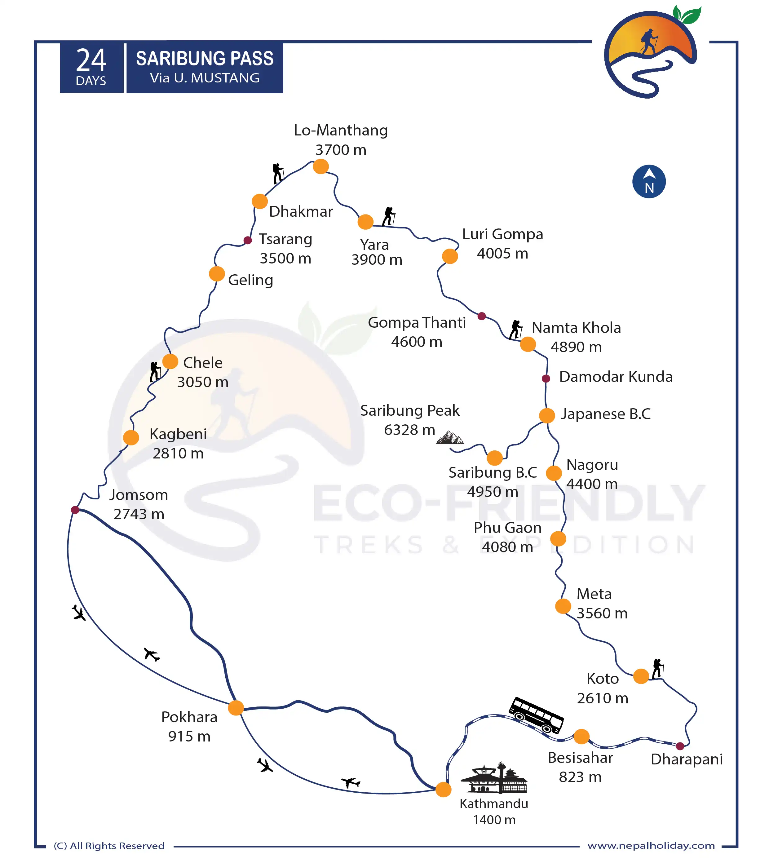
On the way to Saribung Peak Climbing
To embark on the Saribung Peak Climbing Expedition, the journey typically starts with a flight from Kathmandu to Pokhara, followed by a picturesque drive to Jomsom. As you trek through the Lower Mustang area, you will encounter verdant forests and traditional villages before arriving at the arid landscapes of the Upper Mustang. Along the way, you’ll be able to visit ancient monasteries and witness the distinctive cultural practices of the locals.
As you ascend towards Saribung Peak, the terrain becomes more demanding, with steep inclines, rocky paths, and icy slopes. Proper acclimatization is necessary, which involves taking breaks and progressively ascending to higher elevations. Although the climb to the summit of Saribung Peak necessitates previous mountaineering experience, the breathtaking vistas from the peak make the entire endeavor worthwhile.
Experience Needed for Saribung Peak Climbing
Saribung Peak Climbing is a challenging task that calls for a certain level of prior climbing experience. People who want to climb also have experience hiking at high altitudes and using basic climbing gear such as harnesses, ropes, crampons, and ice tools. Climbing requires a certain level of physical fitness.
You need to be in good physical form and have a lot of energy to complete the lengthy and challenging climb, which requires you to walk for hours every day through steep terrain at high elevations.
Hikers are strongly urged to get experience climbing peaks that are at least 5,000 meters in height before attempting to scale the 6,346-meter-high Saribung Peak.
Itinerary of Saribung Peak Climbing
Today, you will spend time getting ready for the trek and ascent. We will set up a meeting with your guide, have a briefing session, and check all of your equipment to make sure it’s in top condition. Additionally, you’ll have the opportunity to explore the area and pick up any last-minute necessities.
From Kathmandu, you will take a flight to Pokhara. The flight won’t take very long, but during that time, you’ll get to see some breathtaking scenery. Once you have arrived in Pokhara, you will be transferred to the hotel. You have the remainder of the day at your disposal to relax and/or continue exploring the neighborhood. You may take a relaxing stroll along the lakeside, or you can take a boat trip on Phewa Lake. Both options are available to you.
We have booked a flight from Pokhara to Jomsom for the early hours of the morning. The flight will last somewhere around twenty-five minutes in total. Take in the breathtaking panorama of the mountain ranges and all of the natural splendor they have to offer. As soon as we reach Jomsom, we will immediately eat lunch and then start getting ready for the walk. After that, we will make our way to Kagbeni by leaving Jomsom and heading in that direction. We are going to arrive at Kagbeni, which is where we are going to spend the night. It is generally agreed that the little village of Kagbeni serves as the entry point to Upper Mustang. When you visit Yak Donald’s, you absolutely must get the Yak Burger.
We shall have an early start in the morning and travel from Kagbeni to Chele. Our destination is Chele. On this day, we will pass the 3,000-meter threshold that we’ve been working for. We are going to walk along the Kali Gandaki River on the breathtaking route that runs beside the river. On our journey, we will pass by two different villages: the first one, which is called Tangbe, and the second one, which is called Chhusang. After that, we are going to make our way to Chele, where we are going to spend the night.
The Chele to Syangbochen walk distance is 11.5 kilometers (7.1 miles). Most of the road is steep, so it takes 6 to 7 hours to finish. The 800-meter difference in height between Chele and Syangboche makes the climb through the Chele to Syangboche walk a very hard job. The best parts of this walk are the views of the mountains, the towns of Ghyakar and Samar, and the Chungsi cave. The Chele to Syangbochen area is popular with people from all over the world because the scenery is clean and beautiful.
You will start your walk by heading in the direction of Gheling, and then continue on to Jhaite Village by climbing up ahead. From Nyi La Pass, which is 4,010 meters in elevation, you will have breathtaking views. After ascending to the top of the pass, you will descend into the Mustang area. You will continue to drop from this point until you reach the pass, and then you will descend once again through a steep trail until you reach Ghami Village.
Trek from Ghami to Tsarang along Upper Mustang’s longest Mani wall, Chhorten, and Chinggel La to get to Tsarang/Charang, which is 3560 meters above sea level. Walking from Ghami to Tsarang, which is 10.7 kilometers or 6.6 miles, takes 5 to 6 hours.
After passing the steel bridge at Ghami Khola, the hardest part of the Ghami to Tsarang path is the steep uphill walk to Choya La at 3870 meters. From the pass, you can see some of the world’s most beautiful mountains, such as Annapurna, Dhaulagiri, Tukuche, Thorang Peak, and many more. From Ghami to Tsarang, there is a trekking route that goes through some rough terrain and has a great view of a remote part of the trans-Himalayan valley. Mustang hiking in Nepal is best known for Tsarang town, a medieval fort, and a red gompa.
The main things to see in Chharang village are the Chorten gate to Tsarang village, the old castle, and the Tsarang temple, which is part of the Gelup sect of Buddhism. The trek from Ghami to Tsarang takes you through some of the most beautiful parts of the Himalayas and gives you a chance to learn about Mustang’s old culture and customs.
The first part of your day will consist of hiking upwards. You will get the opportunity to wander about the Lo-Gyakar-Ghar Gompa. You will continue your journey by hiking along the bank of a river until you settle in Marang. Following the crossing of a small river, you will begin your ascent to Chogo-La Pass, which stands at 4,280 metres and is the highest point in this region. You will descend from this point in order to reach Lo-Manthang, a historic town located in Mustang.
Acclimatization is an essential step for every journey that takes place at an altitude of more than 3000 meters. You will spend the day acclimating your body to the new environment to prepare for tomorrow. You could spend the day trekking all around the village if you wanted to.
In addition, the hamlet is home to a great number of locations where one may gain an understanding of the history and culture of the surrounding area. The area was formerly ruled as a kingdom, and many of the monasteries and palaces that had stood there are still standing today, each looking more magnificent than the last.
The hiking distance from Lo Manthang to Yara is 16.6 km (10.3 mi). It takes around five or six hours to walk to Yaragaon.
The 3700-metre pass is the first thing that you’ll see after leaving Lo-Manthang. Up until it gets close to the Sungda Chhorten, the track is identical to the one that leads to Tsarang. Once you’ve crossed the still bridge, continue on your trek by passing through the villages of Dhigaon and Surkhang on your way to Yaragaon.
You may stop at the Dhi village for lunch and a tour of the surrounding farmland. After taking it easy for a bit, continue on the left bank of the river until you reach Yara.
The walk towards Luri Gompa will just be a short one today. To reach the Luri Cave Monastery, you will have to hike along the river path. You will find two different monasteries in this area. The first is found just under the Luri Cave Monastery, and to go to the monastery from here, you will have to make a somewhat difficult ascent. The construction of these monasteries took place throughout the 15th century. You will come upon an old chorten, as well as pictures and sculptures of several deities and holy literature.
To reach Ghumna Thanti, the hike will take a path that gradually climbs higher in altitude. We are going to walk toward our target for the day while taking in the stunning scenery along the way. You will investigate the surrounding region once you have arrived in Ghuma Thanti. You may obtain wonderful views of the areas that are all around you, and the magnificent Kyumupani River adds even more to the overall splendor of the location.
You will begin the day with a strenuous ascent that will continue until you reach the pass at an elevation of 5,490 meters. From this vantage point, you will get breathtaking views of Dhaulagiri, Damodar, and Annapurna. Once you have descended from this pass, the path will lead you towards Damodar Lake, a wetland area in the Himalayas that is revered as a holy site by both Buddhists and Hindus.
Today will be spent hiking across the Tibetan Plateau. You will make your way up to the high altitude and eventually arrive at Base Camp. Because of the remote location, you will need to bring your own lunch with you. It is strongly recommended that extreme caution be exercised during the route since it is comprised of quite challenging terrain on the way to Base Camp.
You get another day off to relax and recharge so that your body can adjust to the higher altitude. You will embark on a short walk to the hills and investigate the local area when you get there. Wonderful vistas of the mountain range in the Annapurna region may be had from the area immediately surrounding the base camp. Following the day spent exploring, you will make your way back to Base Camp to finish getting ready for the ascent.
Following an enjoyable morning spent taking in the breathtaking scenery, you will set out on the walk that leads to Camp I. Because of the rocks and the snow, the path is going to be challenging. You will make a gradual ascent in the direction of Camp I. You stop to relax and have lunch about halfway through the hike so that you can get your bearings. After arriving at Camp I, you will have the opportunity to unwind amidst the breathtaking scenery of the mountains.
The ascent will start very early in the morning, at one o’clock in the morning. Because the winds in the mountains tend to increase in strength throughout the day, most people start their walk as early as possible. The first part of the walk consists of climbing rocky terrain that features steep hills. After a strenuous hike, you will arrive at the top of Saribung Mountain, which will reward you with breathtaking views of the dense spread of tall peaks that are located in the surrounding region. Chhib Himal (6650m), Kharsang Pinnacle (6225m), and a large deal of the Annapurna region’s other mountains are among those that may be admired from the pinnacle of the mountain. After taking in the breathtaking panorama, we make our way back to Base Camp.
You will go in the direction of the Saribung Pass, which is 6042 meters in altitude. After that, you will make your way down to Nagoru by following a creek that winds its way through the snow-covered route. You are going to give yourself a little pause to have lunch. To reach Nagoru, the walk consists of a series of steep ascents and descents that pass through some of the most breathtaking scenery imaginable.
You will continue your journey over the arid valley located on the Tibetan Plateau. You will get the opportunity to see mountains all around you that are covered with snow. You will arrive in Phu Gaon, a stunning valley that is set apart from the rest of the world. You will get the opportunity to learn about the history and culture of many ethnic groups, such as the Gurung, the Lamas, and the Ghale. You will go to the Tashi Lhakhang Monastery, which is known as one of the oldest monasteries for Buddhists. From this vantage point, you will also be treated to breathtaking views of the Himlung Himal (7,126 m).
As you descend from Phu Gaon, you will eventually reach Meta. You will exit Phu Valley and continue along the route that runs alongside the Phu River. If you keep your eyes open, you could even spot some blue sheep along the way. The lack of human activity in the area contributes to the difficulty of the walk, which is already a challenge in and of itself. You travel down a rough trail to reach Kyang, and then continue on to Chyakhu and Jhunum. You will arrive at Meta if you continue descending.
You will make a hard descent, after which you will walk through an attractive pine forest. In addition to that, you will travel past several stunning streams and a breathtaking waterfall. After continuing, you will get to Koto across a few suspension bridges. If you take the path that runs along Naar Khola, you will end up in Koto. To get here from there, it will take you around six hours of hiking.
Before this Jeep track was built, hikers would follow this route as they made their way for walks. However, despite the potential for a bumpy ride, this route is very beautiful, offering sights of mountains, rivers, gorges, and waterfalls along the way. Arrive in Besisahar in the late afternoon or early evening.
On this day, we take a bus ride back to Kathmandu, which is a journey that would take between five and six hours to complete. Take in the breathtaking views as you travel through the countryside of Nepal. You may spend the latter part of the evening exploring Thamel, shopping for souvenirs, and packing for the next leg of your journey.
Includes/Excludes
What's Included?
- Surface transportation from Besisahar to Kathmandu including members and staff as per the itinerary.
- Road transportation from Kathmandu – Pokhara including climbing members and climbing Sherpa guides.
- Domestic flight from Pokhara – Jomsom including climbing members and climbing Sherpa guides.
- Experienced, and government-authorized (licensed holder) high-altitude trekking/climbing Sherpa guide during the trekking and climbing period.
- Teahouse during the trek as per itinerary
- Breakfast, lunch, and dinner with tea/coffee at the tea house’s menu throughout the trek and camping accommodation
- Essentials for trekking, peak climbing, rowing, and camping at the base camp.
- During the ascent, chief cooks and cook assistants at the advanced base camp who take care of your food and drink.
- 20 kg of personal climbing equipment per person during the flight onboard and during trekking, carried by porter/yak/mules.
- Saribung Peak climbing royalty and climbing permit charged by the Nepal government. (permit issued by NMA)
- Restricted Area Permit for Upper Mustang and Nar-Phu Valley
- The Trekkers’ Information Management Systems (TIMS) permit is required to enter the area of Annapurna Conservation Area, so we provide you with a TIMS permit too.
- Wages, clinical, equipment, and accidental insurance for all elaborate staff in the journeying and climbing.
- Satellite phones with your climber Sherpa guide.
- North face tents with comfortable mattresses at the advanced base camps and high camps for members and involved staff.
- Static rope, ice screws, snow bar, rock piton, and karabiners to open the route and fix the life for safe and successful climbing.
- Clean, nutrition high altitude packaged food and essential EPI cooking gas and stoves to boil water, tea, coffee, and warm pocket food.
- Medical insurance, helicopter evacuation insurance, and treatment insurance for all involved staff with a reputed insurance company.
- Maps and climbing certificates for the climbers.
What's Excluded?
- Food and accommodation during the Kathmandu Stay
- International flight ticket.
- International airport tax
- Visa Fee
- Sightseeing in Kathmandu
- Tips for staff and guides
- Trip Insurance
- Personal costs like drinks, laundry, hot showers, bottled water
- Personal climbing equipment and clothing
- Anything that is not listed in the “PRICE INCLUDES” section above
Essential Information - Saribung Peak Climbing
Best Time for Saribung Peak Climbing
The ideal times for Saribung Peak Climbing are in the spring (March to May) and fall (mid-September to November).
Because the weather is pleasant and there is less snow on the slopes during these times, it is an ideal time for climbing and hiking in the mountains.
Climbing should be avoided during the monsoon and winter months because the trails are muddy and slick, the weather is bitterly cold, and the vistas are not as spectacular at these times.
Physical Preparation for Saribung Peak Climbing
You must be in great physical condition and have sufficient energy to complete the long and difficult hike, which requires you to walk for hours each day over steep terrain at high altitudes.
Before attempting to mount the 6,346-meter-high Saribung Peak, hikers are strongly encouraged to gain knowledge of climbing hills that are at least 5,000 meters in height.
Saribung Peak Climbing Accommodation
During Saribung Peak Climbing, there are numerous tea houses, lodges, and shelters for camping that serve as lodging options. These are simple but comfortable hotels with shared bathrooms and simple rooms.
It is essential to keep in mind that the number of these accommodations may be limited, and thus, it is recommended to make reservations in advance.
As you get closer to the peak, the number of tea houses and hotels gets smaller, so you have to camp. The climbing groups will set up tents for you at spots along the way. Most of the time, these places have tents for eating, tents for sleeping, and toilets.
Most asked questions
FAQs about Saribung Peak Climbing
Saribung Peak (6,328 m) is situated in a remote area of the Mustang Region, near the Chinese border.
The elevation of Saribung Peak above sea level is 6328 meters.
In our package, we have made a plan for 24 days. The package is well thought out, but if you want to add more days, please let us know during the inquiry. We are happy to customize the trip to fit your requirements.
Saribung Peak Climbing has no set age limit; anyone over 18 can climb the peak. However, the climbing is physically demanding and requires a high level of fitness.
You will need a Saribung Peak climbing royalty and climbing permit, a Restricted Area Permit, and a TIMS permit.
During the climbing of Saribung Peak, joining the group is not required, but doing so could result in a reduction in the overall cost of the excursion. Nevertheless, you may schedule us if you wish to climb solo with our team or if you have your own group.
You should read up on the safety measures you can take before and during your journey. It is smarter to mentally prepare for the trip and know what safety measures to take ahead of time.
Make sure to let your guide know if your health changes while you are on the trip. Your guide will be with you the whole time to help you.
Reviews on Saribung Peak Climbing
Be first to post a review in this trip.