
Trip Introduction
Overview of Annapurna Circuit Trek
The desire to be a part of the Annapurna existence indicates a certain level of awareness in you. Furthermore, there is a strong possibility that the level of interest in the Annapurna Circuit Trek will reach a higher level of blissful fullness. Its realization and transformation allow for recreation, joy, enjoyment, and pleasure.
Annapurna was named after the Hindu goddess of food rather than a person. You can enjoy going along a trail that translates literally to “full of prosperity,” where “Anna” represents food and “purna” represents fullness.
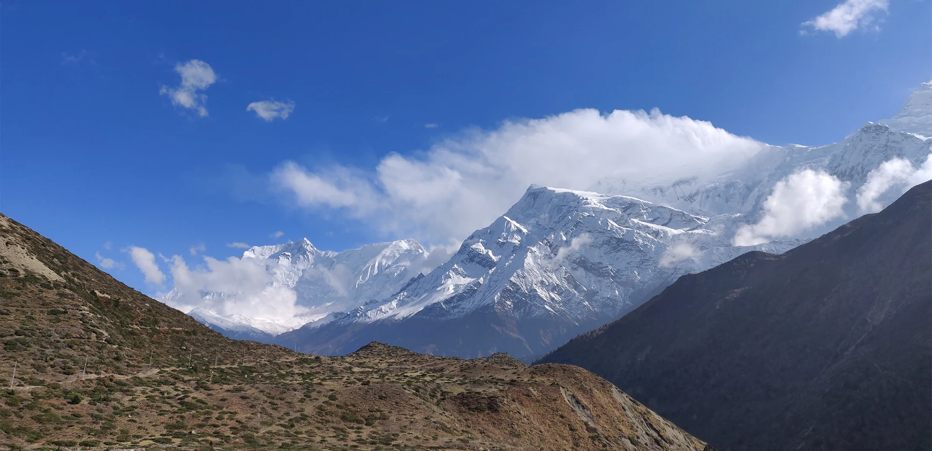
The Annapurna Circuit Trail brings you from a low loop of the Annapurna massif to pine forest at higher elevations through barren landscapes, revealing a spectacular mountain range in the Annapurna region. Consider the majestic Mount Annapurna’s panoramic views and their astonishing existence. As you pass through the remote villages, your level of awareness assists you in discovering the inner strength of the surroundings.
We lead you to the Annapurna Circuit route by following your inner transcendent desire to be in the Himalayas. Our advice is intended to assist you in your pursuit of recreation, joy, bliss, and excitement.
Annapurna Circuit Hike
Immerse in the forest, connect with nature, and forget about the constant pings of their phones and other people’s demands on their time and energy. Being out in the fresh air and surrounded by natural beauty enhances our senses and helps us tune in to our inner experiences.
Hiking in Annapurna Circuit is guided to unionize extreme divisions, which brings you to oneness. As you walk through Annapurna’s existence, your level of awareness helps you find the inner power of your surroundings.
We organize a fixed departure for the Annapurna circuit hike in September, when the weather is best for trekking. Core trekking in Annapurna Circuit is all about getting to know the local people and getting close to the dazzling peaks and hills.
Annapurna Circuit Yoga
Appreciate and reconnect to the land of Annapurna, nature, and yourselves. Yoga during the Annapurna Circuit is all about bringing your regular yoga practice into direct connection with nature. Yoga in nature is best when it comes to finding union with the natural world.
Practicing yoga in nature may help people feel more connected to nature and more at peace with one’s self. Being in Annapurna Round and relaxing your body in nature restores us to an awakening state. The departure date has been set for June, when conditions are ideal for yoga.
Annapurna Circuit Celebration
Life is all about being happy, and social interaction with other people not only makes us happy but also helps us learn more about other cultures. The Annapurna Circuit celebration is a mix of trekking and the celebration of Nepalese festivals.
The celebration at Annapurna Circuit will start in April on the occasion of the Nepali New Year. Let’s take a break from our hectic schedules to celebrate this holiday together.
Itinerary of Annapurna Circuit Trek
Before your trip, we must ensure that all paperwork and other preparations are made. We will also have a meet-up and pre-trip discussion with the trek guide in our office.
The first day of this Annapurna Round itinerary is a travel day with an adventurous ride. The journey time from Kathmandu to Besisahar can range from 6 to 8 hours, depending on traffic, road conditions, and the number of stops. After the rough ride on even roads, we finally reached Besisahar.
After reaching Besisahar, we will take an additional less than 1-hour ride to Bhulbhule. The first section of the road is along a gravel road with significant elevation changes, making the ride easy. You will follow the river with a nice view of green hills, valleys, and surrounding mountains. After some minutes of walking, we will reach the Annapurna Conservation Area Checkpoint and register our permits there. After that, we will continue our ride to reach Bhubhule.
Today, the walk is not as luxurious as yesterday. We set off after the early morning breakfast towards Ngadi. Continuing along the road, we will cross the small village of Ngadi. This flat section is comprehensive and easy to follow. We will then cross a small waterfall and a hydropower station.
As we climb higher, beautiful views of the valley, river, and surrounding mountains will open up. The path will continue past agricultural crops and slopes, where local women care for crops in the morning light while men work in nearby communities.
After reaching Bahundanda, the climb to the village was pretty tough, especially in the morning heat. This village is the highest point of today’s trekking, and after taking in the views, the trail took us back down into the valley. You will get a good flavor of rural Nepalese communities and an insight into what life was really like in this part of the country.
After some more walking ahead, we will reach Jagat and then Chamje. To reach today’s destination, we will pass through stone stairs, waterfalls, and green valleys. After like an hour of trekking, you will arrive at Chamje overnight.
After the early morning breakfast, you will start to descend the steps towards the water and cross the raging river via the first suspension bridge of the day. Today you will experience the spectacular verdant landscape, which was not something you expected. Continuing, we soon came to a gate welcoming us to the Manang district. After some hours of walking, we descended towards the river and headed to the Tal village.
After some rest, we will start our walk along the path, which is now squeezed between the river and the imposing cliffs. You will continue to walk, tackling other small villages, terraced fields, and suspension bridges. After about 4 hours of walking for Tal, we will reach Dharapani and Danaque.
We set off after the early morning breakfast for the Timang. Slowly the landscape starts to change, and you will feel the altitude as we trek higher. The area was almost alpine when you reached the Timang. During the walk, you will start to see the cows grazing in the grass-covered meadow, taller snow-covered mountain summits, and small waterfalls. After some memorable walk for some 3 hours, you will reach Timang.
The path now meandered through pine forests, past waterfalls, and between villages. Now and then, it veered off the dirt road to wind through needle-covered forest paths. Following the zig-zagging trail along a rushing river and cattle grazing happily, you will reach Koto. There is another checkpoint where they check the permit and TIMS card and register my details.
As we walk further, we will reach Chame village and then follow the river. As we walk, the trail passes through green fields before heading through a dense pine forest. After an hour of different walks from here, we reach another village home to an apple farm with its cafe and accommodation. Pushing on, we will continue on the path, which goes up and down for a while as it hugs the cliffside. After crossing the tricky trails, we eventually cross the bridge, and the path will ascend sharply to the pine forest. We will continue climbing through the forest before the path reaches the village of Dhukur Pokhari.
After the early breakfast, we head toward the valley of Lower Pisang. We will pass through lakes, grass fields, and snow-covered slopes as the river meanders between Lower and Upper Pisang. Today the walk will be more challenging than previous days, but it also offers some of the most incredible views. You will also reach above 3600 meters, so remember about altitude sickness.
Today is a long walk as you will cross many villages: Ghyaru, Ngawal, Braga, and finally, Manang. As you are near Manang, you will witness the beautiful stupa and a different landscape than before.
From now on, you will cross an altitude of more than 4,000 meters above sea level, so acclimatization in Manang is essential. At this point of height, we will be preparing ourselves with a 5416-meter altitude pass. It is necessary to prepare your mind and body well at this altitude.
You have many options for hanging out in Manang. If you want to explore more around Manang, there are plenty of activities to do. You can hike to the Ice Lake, which will take around 7 hours on a return trip. If you want to hike less, you may visit Tilicho Lake, the highest lake in Nepal. If you don’t like walking much, you can hang around Manang, visiting the restaurants, bakery shops, and stupas.
The seventh day of our Annapurna Circuit trek was one of the shorter but most memorable. We’ll be traveling from Manang to Ghunsang and Yak Kharka today. Stunning mountain views make it an enjoyable day during the walk. The path is pretty narrow in some parts, passing the mules and yaks. You will cross a couple of suspension bridges during the walk and hike.
We eventually arrive in Yak Kharka, where most people stay the night to avoid exceeding height.
Our ninth day of trekking will be the shortest, but with good reason: it is the final day before trying to cross the 5416-meter Thorang-La Pass. Today’s itinerary would take us from Yak Kharka to Ledar, then to Deurali, and lastly to Thorong Phedi.
Our tenth-day trek will be one of the toughest yet most incredible of the entire trek. This route would take us from Thorong Phedi to High Camp, Thorong-La Pass, and finally to Muktinath. Today is the day we will eventually attempt to cross the Thorong-La Pass. At 5416m. As you wake up at 4, you will have breakfast and start your trek. As we ascend higher, you feel like walking over bare mountain peaks with piles of snow and ice along the path. After 3 hours of strenuous walking, you will finally reach the pass. Your heart will fill with joy as the beautiful peaks surround you.
After some rest, we will start our hardest part. This was the most significant and prolonged descent of the entire trip, and our knees felt challenging to control. The trail will be slippery, and everyone will find walking difficult because of mud or loose gravel. After around 4 hours of walking from the high pass, you will reach Muktinath.
Our eleventh day of walking takes us to the dusty trail with access to the road. Instead of the trekking trail, our route will take us along the newly paved road out of Muktinath. You can check out the village of Kagbeni, which serves as the gateway to the remote Upper Mustang region. The landscape will be arid here, but you can still trace green vegetation. After walking further into the unpaved roads, we finally reach Jomson.
We will catch the early morning bus to reach Pokhara. During your ride, witness the impressive view of the dazzling peaks and several green hills. After the adventurous ride, you will reach the beautiful city of Pokhara.
The 13-day Annapurna Circuit Trekking itinerary is only for guidelines. You can customize the trek according to your taste. The above trekking hours are also estimated for general ideas only. The itinerary also depends on traffic and weather conditions on your activity date.
Sometimes, a few changes in the itinerary may happen due to last-minute changes in government rules, transportation schedules, or natural calamities like floods, landslides, etc.
Includes/Excludes
What's Included?
- A guide to managing the entire holiday.
- Basic yet comfortable accommodation on a sharing basis during the trekking as per itinerary.
- 13 breakfasts, 12 lunches, and 12 dinners are served from the locals’ kitchens during the trekking as per the itinerary.
- Purified drinking water during the entire trekking as per itinerary.
- Annapurna Conservation Area trekking permit.
- Tourist Bus from Kathmandu-Pokhara-Kathmandu.
- Bus from Jomsom to Pokhara
- General first aid medicine kit.
- One porter for two of you for trekking (prepare to give max. 15 kgs’ luggage from each of you so that it will not exceed 30 kg. for your porter).
- Complimentary T-shirt
- Duffle bag during the trip.
What's Excluded?
- Food and Accommodation in Kathmandu and Pokhara
- Personnel expenses of any kind
- Any Travel Insurance
- Any additional cost due to natural calamity and unforeseen circumstances might affect itineraries
- Tips for any staff and guide
- Costs associated with evacuations due to illness, accidents, or other natural disasters like earthquakes, landslides, floods, etc.
- Anything that is not listed in the “PRICE INCLUDES” section above
Special Group Discount Price
| Group Size | Price |
|---|---|
| 1 Person | US$ 956 Per Person |
| 2 People | US$ 718 Per Person |
| 3 People | US$ 658 Per Person |
| 4-6 People | US$ 634 Per Person |
| 7-9 People | US$ 614 Per Person |
| 10-12 People | US$ 611 Per Person |
| Over 12 People | US$ 605 Per Person |
Essential Information - Annapurna Circuit Trek
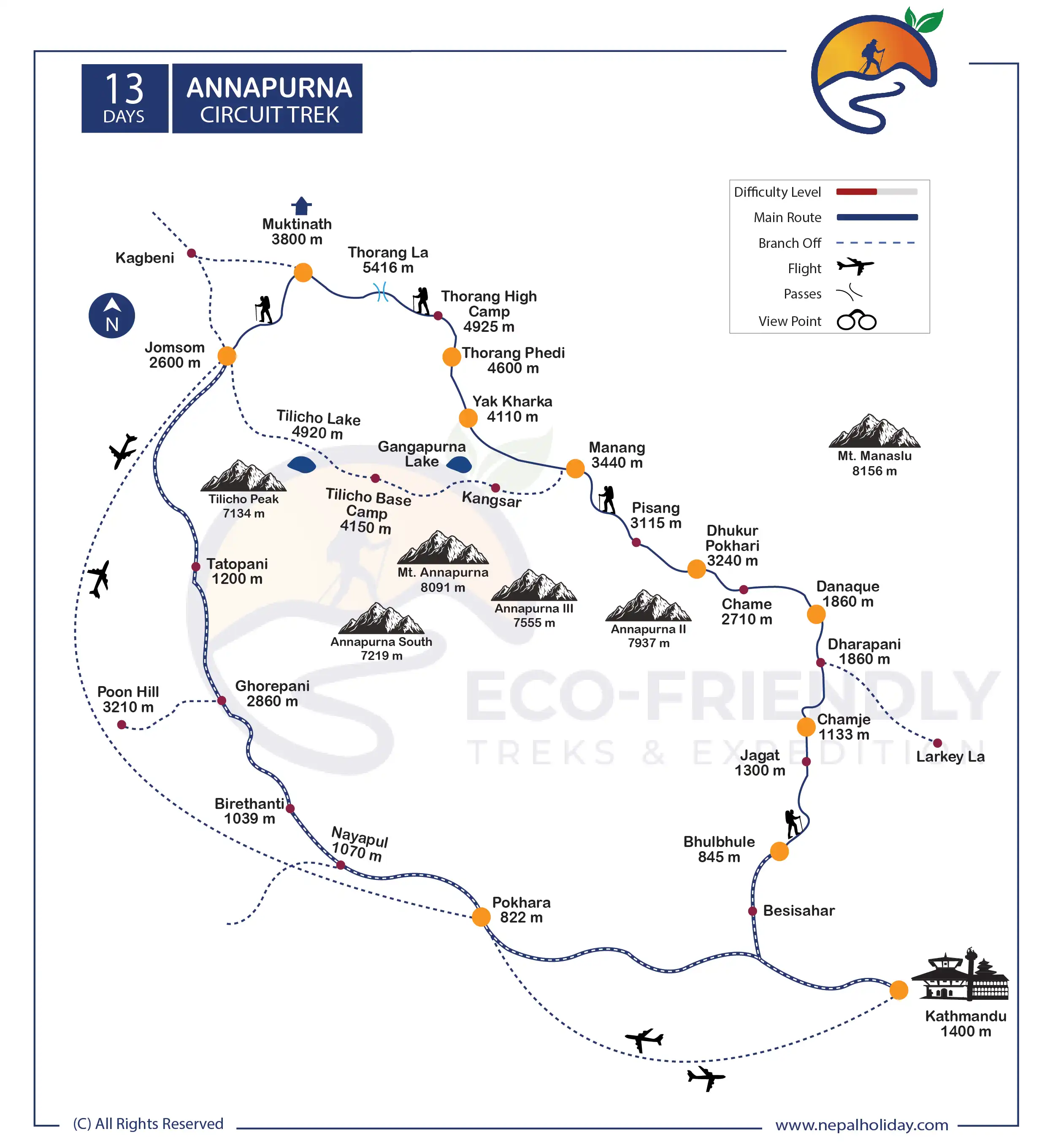
Annapurna Circuit Trek Route Map
Are you wondering about the map of the Annapurna trek? If you click on the infographic image below, you will see the route map for Annapurna Circuit.
We have designed the digital map for simplicity and practicality and to enhance your trekking experience. In addition, this map portrays the extension trails, peaks, rivers, and religious sites. Click the infographic image below to learn about the route.
The Annapurna Circuit Trek distance is 13 days, starting with the scenic drive from Kathmandu to Bhulbhule. The distance of the Annapurna Circuit trek is about 160 to 260 kilometers. The distance differs between the days of the itinerary and the trek start point. Our trek starts ahead of Chamje, Dhuku Pokhari, Manang, Phedi, and Thorong La. We then begin to descend to Muktinath, Jomsom, and then Pokhara. On the map, you will see the extension route too. Upon your interest, we can also extend the trail to Upper Mustang for more exciting views.
Annapurna Circuit Trek Difficulty
The Mount Annapurna Circuit Trek cannot be considered a challenging trekking route in Nepal. It is moderate-level trekking, yet it is the longest trekking route in the region. So, it can be challenging for a beginner trekker to complete the journey without prior training and preparation.
One of the causes of the Annapurna Circuit trek difficulty level challenge is that the route takes you to a high altitude. The highest elevation pass in the area, Thorung La, is reached by following the trekking path, which rises to a height of 5416 m. Due to the severe cold and severe snowfall, this section of the trek is incredibly challenging and is blocked for most of the year.
You may avoid some path sections to make your walk more accessible. But by doing so, you will have to cut off the best features of this journey. The only way a trekker can better tackle the challenges of the Annapurna Circuit trek is to get physically ready for the trip. Travelers can boost their strength, capacity to adapt to their surroundings, and trekking abilities by engaging in some daily physical activity.
Accommodation on Annapurna Circuit Trek
Accommodations along the Annapurna Circuit trek have electricity, a hot shower, and wifi free of charge. These kinds of facilities aren’t typical for many other trekking trail guesthouses.
At higher altitudes, the services are relatively essential, i.e., Thorong Phedi and High Camp. The accommodation lacks power outlets, limited wifi, a hot shower, etc. You must pay extra to use the wifi or to charge your phone.
Lodging in Annapurna Circuit that is appropriate for tourists will be available. The infrastructure, including accommodations and roads, has expanded along with the tourism industry. Essential yet comfortable services, such as cozy beds with pillows and blankets, are offered.
Food on Annapurna Circuit Trek
Food on the Annapurna Circuit Trek is easily accessible unless you have exceptionally tight dietary requirements. You don’t need to bring or pack food because every hotel offers various cuisines and vegan and gluten-free options (rice). Every settlement has a store where you may get trail food like fruits, nutrition bars, junk foods, etc.
However, the two most essential trekking components are generally food and drink. If you are not consuming appropriately and healthily, no amount of training or planning will be adequate. To stay active and healthy throughout your journey, we strongly advise avoiding junk food and staying hydrated.
Best season to trek Annapurna Circuit
Since spring and autumn offer more tolerant weather and improved hiking conditions, most people prefer to walk in these seasons. The best months to trek Annapurna Circuit are generally regarded as October and November or April and May. The weather is typically straightforward and dry when traveling to high altitudes during these two seasons.
Altitude Sickness & Acclimatization on Annapurna Circuit Trek
Altitude sickness can be fatal, with symptoms including shortness of breath while lying down, lightheadedness, loss of coordination, and vomiting. The best treatment for all symptoms is to descend, rest, and ascend again.
To avoid the side effects, it is critical to acclimate slowly during the Annapurna Circuit trek. Furthermore, most guides will ensure you sleep at a lower elevation than you reached that day. Aside from that, eat well and stay hydrated. If you notice any changes in your health, consult with your guide, because they will recognize if your symptoms are severe or not.
Annapurna Circuit Trek Packing Suggestions
Please properly pack your luggage for the porter (each of you weighs 15kg; for two of you, a porter is arranged). You will leave the rest of your luggage behind at your hotel until the end of this holiday. Below is a loosely advised Annapurna Circuit Trek packing list that might help you on your trek:
- Appropriate clothing (3 sets)
- Woolen sweater or jacket
- Thermal inner wear
- Wide-brimmed hat
- Woolen cap and scarf
- Thick woollen gloves
- Waterproof gloves
- Sport Sandals
- Woolen socks (2 pairs)
- Waterproof (not water-resistant) shoes with a good tread/grip
- Rain-proof pants and jacket with hood
- A lock for the duffle bag
- Backpack with waterproof cover
- Sleeping bag suitable for temperatures around 0°C (1 – optional)
- Down jacket with hood
- Camera (optional) (video camera is not permitted by authority)
Other essential items:
- Personal clothing
- Toiletries
- Small thermos for hot beverages
- Water bottle (1 litre)
- Sunscreen lotion (50 SPF or more)
- Castor oil (50 ml) to lubricate the nostrils at high altitude
- Ziplock bags for clothing
- Quick-dry Towel (not a regular one)
- Toilet paper
- Wet wipes
- Sunglasses
- Snacks: chocolates, biscuits, nuts, etc.
- Hand sanitizer
- Powerful flashlight or headlamp (with extra batteries)
Medical Kit
Though we arrange basic medical kits for Annapurna Circuit Trekking, they are very general and may not be adequate based on conditional necessity. Personal medical equipment includes electrolyte packs, painkillers, muscle relaxant creams, band-aids, knee caps, medicines for fever, common cold, headache, nausea, vomiting, diarrhea, indigestion, and other personal medication that is necessary from your side.
Communication in Annapurna Circuit Trek
The Annapurna Circuit trekking itinerary encounters different landscapes. Even in this age of highly modern information and communication technologies (ICT), it is challenging to approach her development in remote Annapurna. One cause is still not correctly developing the technologies in remote Annapurna. As communication is significant in such an area, a guide has a mobile that may help connect you. Though it is not as reliable as in the urban areas we generally live in, much ICT has been developing. WiFi may be available in some places on this route.
Annapurna Circuit alternative trek packages
If you are willing to extend your Annapurna Circuit Trekking holiday, we have other Annapurna alternative trek packages. We believe that we all have different choices while traveling, so we are ready to design an alternative package to suit your taste.
Annapurna Base Trek is one of the best alternatives for your trip if you want to visit Annapurna on a slightly shorter day than Annapurna Circuit. If you want a very short trek in the Annapurna region without doing a circuit, we have Ghorepani Poon Hill Trekking and Mardi Himal Trekking for you.
We also have some luxury lodge trips to the Annapurna region, in case you want more facilities in a remote mountain. You will also have the choice of doing a helicopter tour to Annapurna Base Camp.
Annapurna Circuit Trek Permit
Every person who wants to complete the Annapurna Circuit trip must have one of two trekking permits. The two permits are (Trekkers’ Information Management Systems) TIMS and (Annapurna Conservation Area Entry Permit) ACAP.
For TIMS, the Nepal Tourism Board (NTB) and the Trekking Agencies Association of Nepal (TAAN) have jointly implemented this essential permit to ensure the safety and security of any trekker in Nepal.
For ANCAP, a permit is required for all trekkers who want to travel in the Annapurna region. The National Trust for Nature Conservation handles its management, and a portion of the ANCAP fee supports the trust’s efforts to protect this stunning area.
Note: Please keep 8–10 passport-size photographs with you, which will be asked for while making government documents.
Most asked questions
FAQs about Annapurna Circuit Trek
For decades, living in the Himalayas enabled one to be and realize an unnecessary division of happy completeness. Your existence in the mountains, whether as a pilgrim or a hermit, has long been associated with achieving joyful wholeness.
Himalayan or mountain ranges and hermits in the forest are Zen topics to Jesus Himalayas that can bring together unnecessary divides and facilitate joyous recreation.
With this in mind, we firmly think that hiking in the Annapurna Circuit Trek is more than simply a vacation; nevertheless, how you experience it will depend on your level of interest and awareness.
Thorong-La pass (5,415m), the tallest altitude on the Annapurna Circuit, is the most rigid portion of this trek. The location is a well-known viewing point in the Annapurna range.
Following their physical state, beginners can hike to Annapurna Base Camp. You do not need other climbing or skills; our package covers trekking on rough trails. Therefore, you will be prepared for the ABC journey if you are well-equipped to overcome the fear of walking on those trails.
Just be careful to train yourself three months before the walk by doing simple workouts like running, breathing exercises, or swimming. Beginners might be afraid of spending the entire day on the rocky paths, but being fully physically and mentally prepared will give you more confidence to take on the challenge.
An entrance permit is required if you visit the Annapurna region for any purpose. A unique trek permit is always necessary to reach the restricted areas of Nepal where the government has authorized trekking. TIMs and an Annapurna Conservation Area Permit are also required for the Annapurna Circuit travel permit.
Your safety when you enter the protected zones is directly related to the permission. It guarantees your safety while trekking in particular places, and the money you pay is also used to improve the environment and make it more welcoming to tourists.
The package we have designed for our fixed departure cannot be changed, increased, decreased, or otherwise modified. For that, we offer a customized package, and you are free to look at your options and increase, decrease, or change the activities. You can count on our team to make your ideal package a reality.
The schedule we provide is also one of the shortened itineraries of the region that we have created, taking health and other considerations into account. High altitude sickness and other problems may result from insufficient time to adjust to changing temperature, humidity, or pH. Your body needs time to produce more red blood cells to compensate for the blood’s lower oxygen levels at high altitudes. If you are incredibly new to high elevations, cutting your journey days short could be unhelpful for your body.
In addition, if you wish to stay longer in the Himalayas, we provide the best alternative options for extending the days and tailoring your itinerary to suit your demands. Please do not hesitate to contact us; we will put together your perfect package with the help of our team and you.
You must go with an Annapurna Circuit Trek guide if you buy the package from a trekking company. When you book a local company like us, we are concerned about your security. If you travel with a guide, the group will always provide you with a more incredible selection of lodging, food, and other necessities to make your walk easier overall. You will always have someone to give you the best possible ideas during your trek.
It is not compulsory to take a guide for this trek if you are an independent trekker, but your trek will be hassle-free if there is a guide with you. We highly suggest you go along with a trekking agency to hire a guide, especially if you are traveling to high elevations for the very first time.
Furthermore, if you have severe altitude sickness, you will have trained experts to keep an eye on your symptoms immediately. They will help you learn at every step because they are experienced with such high elevations and fauna.
The majority of the communities in the trekking region now have connections to small micro hydro, making energy available. Public spaces like dining establishments, lodges, and tea shops typically offer to charge stations for your electric devices.
Some locations charge extra for electrical gadget charging. Nowadays, many carry smaller, foldable solar chargers that let them charge their devices while walking.
You can also bring an extra battery or a portable power bank as a backup. It is essential to have spare batteries on hand in case of power outages or low voltage.
It is essential to check health and fitness as you travel through high-altitude regions. It helps to ensure a safe and comfortable experience for all the trekkers.
We are pleased to have you visit Annapurna Circuit with your kids and family since we think nature benefits children in various ways. The journey may be completed without incident with a qualified guide.
For at least a month, get your kids in shape for this walk by having them practice easy exercises and breathing techniques. Please let us know during the inquiry if you require a kid carry service.
Even though the flights between Kathmandu and Pokhara are usually reliable, they could be delayed for a while or even an entire day in extremely rare cases. But to be safe, we advise you to reserve a few more days in Nepal.
If your flight to or from Kathmandu is delayed, we will rebook it for the following day. As an agent, we will make every effort to coordinate with airlines to ensure you have a comfortable trip.
Extra hotel stays and food are not included in the package; if we need to stay overnight waiting for your flight the next day, we can arrange food and lodging at your request.
Before beginning the journey, we already impose payments on several costs, including permits, taxes, and others. Please be aware that this remains the same as we must fully compensate our guides and porters for the time they have committed, even if you choose not to finish the entire trek. We find it very difficult to issue refunds for any reason.
Sometimes hikers finish their journey sooner than expected or terminate it early for personal or health reasons. Kindly be aware that we do not grant refunds for any portion of the trek that is not used. This also depends on the circumstances, but we request you not to expect any refund for the above reasons.
Specific fees apply if you desire to cancel your reserved trips. Behind that, we welcome you to shift your trip plan if you want changes in the booking date or destinations.
We may charge a specific amount if we have already completed some of your reservations on the previous booking day if you wish to reschedule the booking date. Both parties will benefit if you inform us as soon as possible. Please go through our terms and conditions to clarify the refund process.
Our target for a fixed departure is 12 visitors. If the visitor does not reach 12 within the given mentioned period, the trip will be shifted to a customized package, which brings a change in the price including terms and conditions. We will surely let you know about every change.
Due to the party size, we offer you a very affordable price on a fixed departure. The program will be revised following the trip that has been reserved if the group criteria are not met. Go through the other pricing if you want to book the trip on your own date, or contact us if you need to customize your trip.
Note: We do not customize the program of fixed departure. Please get in touch with us for the unique customized package if you want to create your own itinerary rather than taking part in a fixed departure. Our team will happily assist you with their experienced advice and recommendations.
Starting before three months of your vacation, we strongly advise you to get active in order to mentally and physically prepare yourself. Additionally, we offer the Soldhunga Hike as part of our quick acclimation training trip. You can utilize this hike as a very tiny preview of what to expect on your main journey in the central Himalayas.
We request you ask our ground team in Kathmandu for assistance with arranging day tours around the city. If you still have time extra few days or a week after the trek, we can also arrange one of the following quick relaxation trips. Feel free to pick the one you think will best suit your interests.
- Lumbini
- Chitwan Safari
All of these additional vacation days were planned with the idea that you would want to relax after a hard and long trek rather than go on hiking again. Please let us know if there are any other destinations you would like over these ones.
Reviews on Annapurna Circuit Trek
![]()
![]()
![]()
![]()
![]()
Based on 9
Reviews

Marius Sandvoll Weschke
Horten, Norway
There is nothing bad to say about the trip arrangement!
I was picked up at the hotel with a warm welcome and on time. The hotel in Kathmandu was good. The bus we took was a tourist bus which took us to the starting point without any problems.
The guide was an excellent one. He was never as far as I noticed in a bad mood. He did not stress about the things we did and helped me with my opinion on matters. I am very pleased.
There is nothing bad to say about the trip arrangement, everything went as it should and that was very pleasing. I would like to recommend travel experiences to others as very important especially when they have worked out well.
Mrs. J. Sivagnanasundaram
England
Moti gave us all that we needed
No delay and a friendly welcome to Kathmandu by the expedition organizer Krishna with a SMILE !! Drove through the narrow streets, which were very busy. The hotel room was okay, but not very pleasant. The breakfast serving was good, very clean, tidy and well-presented to start the day.
The trekking guide and our helper were strong and they were really helpful, cheerful and even knowledgeable. The food on the way was excellent. Moti gave us all that we needed and looked after us well.
The trip management was excellent, warm and friendly. Ride on the elephant to see the wild animals was excellent as it was not by a 4 wheeler.
Martin Eggert
Sinzig, Germany
I would like to recommend them as your trekking partner
The airport pick-up service was quick, friendly, efficient and helpful. They waited for us with the name sign in their hand. The hotel and breakfast in Kathmandu were good and satisfactory.
Our trek guide is the best and his way matches our hopes. We came open for the adventure and every day he made us meet it. He was well-organized and cared for us a lot. Everything was new for me and I liked the way to live up there.
I would like to recommend them as your trekking partner as they are strictly oriented to our individual wishes and are extremely kind. Thank you for making our holiday amazing!
Simon Eggert
Koblenz, Germany
Everything worked as planned!
The airport pickup was very warmly welcome and the driver and guide were very friendly. The hotel in Kathmandu was very good, better than last time: clean and nice rooms. The breakfast service in Kathmandu was very good, nothing to complain about it.
Our guide was very outstanding! They took us to very interesting places and told us nice stories. He knew a nice restaurant and took us there. We felt like we were being guided by good old friends. The driver was good and drove us safely everywhere.
The trip guide could read our wishes and problems face-to-face and ensure safe trips. I think we have become friends and will stay in contact via email.
Everything worked as planned and maybe try to book lodges before the trip during the season. I would like to recommend eco-friendly because I know everybody is in good hands while trekking with them. The company organizes everything and also 10% of eco projects are important to me.
I hope I can come back and will have lots of more treks and trips to Nepal especially with Eco-friendly treks.
Nitish Kumar Dutt
Kolkatta, India
Trek guide was very good!!
The airport pickup service was very good and they took us to the hotel. It was on time and the hotel location was in the center of the city. Our trek guide was very good, a nice person and helpful.
Stefanescu Ionvt
Piatra Neamț, Romania
I already spoke for arrange our next trip in Nepal!
The trip was well-managed and went as planned. Our trip guide was very knowledgeable, helpful and friendly during the trek. Ecofriendly is a big agency with a very good guide, porters with good fame and a smart director.
I would highly recommend an eco-friendly trek and I already spoke with my friends to arrange our next trip in Nepal!
Kara Faulconbridge
Toronto, Canada
You have taken very good care of us and helped us!!
It was great to see a friendly face at the airport after such a long journey! It really made us feel welcome and special. The service was very friendly and helpful. Nice shower, beautiful entrance and nice decoration. Great location and runs professionally.
The Kathmandu Valley sightseeing was the best part and getting a chance to meet Pawan before going on the trek. We liked doing all 3 temples in 1 day, which gave us a little taste of everything. I did not feel too rushed.
The trek guide was very knowledgeable and patient, kind and friendly. It was fun to relax at the end of a long day together. Stayed close when we needed a little help and also gave us alone time while walking. Pawan chooses great lodges with friendly people and comfortable beds.
Krishna paid attention to all details and responded to questions and concerns quickly and helpfully. The recommended trek was well-managed and planned. We would definitely recommend your company because of its professionalism and excellent customer service. The experience of your staff is great.
We feel that the eco-friendly trek and expedition played a big role in making this the best trip of our lives. We love Nepal and have learned so much. You have taken very good care of us and helped us have an amazing experience. It was great to not have to worry about things like booking transportation and other logistic items.
Andrew Humphrey
Outdoor service and was excellent and the staff were fantastic too!
This was very efficient, somebody was waiting for me. The hotel Thamel was very satisfactory to my needs. The sightseeing tour was good and took in many places of interest.
My guide and porter were excellent and they were accommodating to all my needs. The lodges we stayed in were good and the food was excellent. All services were good and communications were very prompt.
The farewell dinner was excellent at my guides house. The trip arrangement capacity of Eco-friendly was excellent. I would like to recommend the outdoor service and was excellent and the staff were fantastic too!
Joseph Faust
Rochrmoos, Germany
I never got the impression of a only client relationship!!
There was no problem with the pick up service. Maybe we would have needed some help with the beggars. We just arrived and did not know how to react. The hotel was very luxurious and secure. Everybody was very kind to us and the hotel is really in the center of Kathmandu. The breakfast service was very good with Western standards and good local food, which I wanted more.
The second day of our stay in Kathmandu was good and we visited a few sites. Maybe some instructions would be good, how to reach beggars or these guides. Those illegal guides were good but I did not have any idea how much money we had to give. The driver was very good he did not speak English but he led us through the chaos in Kathmandu very safely.
We had the best team ever in the trek. Our guide Moti and our porter Pemba were impressive. They were not just friendly to us, they were really good friend while trekking. We laughed so much together and I never got the impression of a only client relationship.
Everything was so well arranged and there were no problems with the management, who solved it immediately. I think of course I would like to recommend it. Everything was well organized and everybody was really interested in satisfying us.
© Copyright 2024 Eco-friendly Treks. Website Developed by: AVIVA